


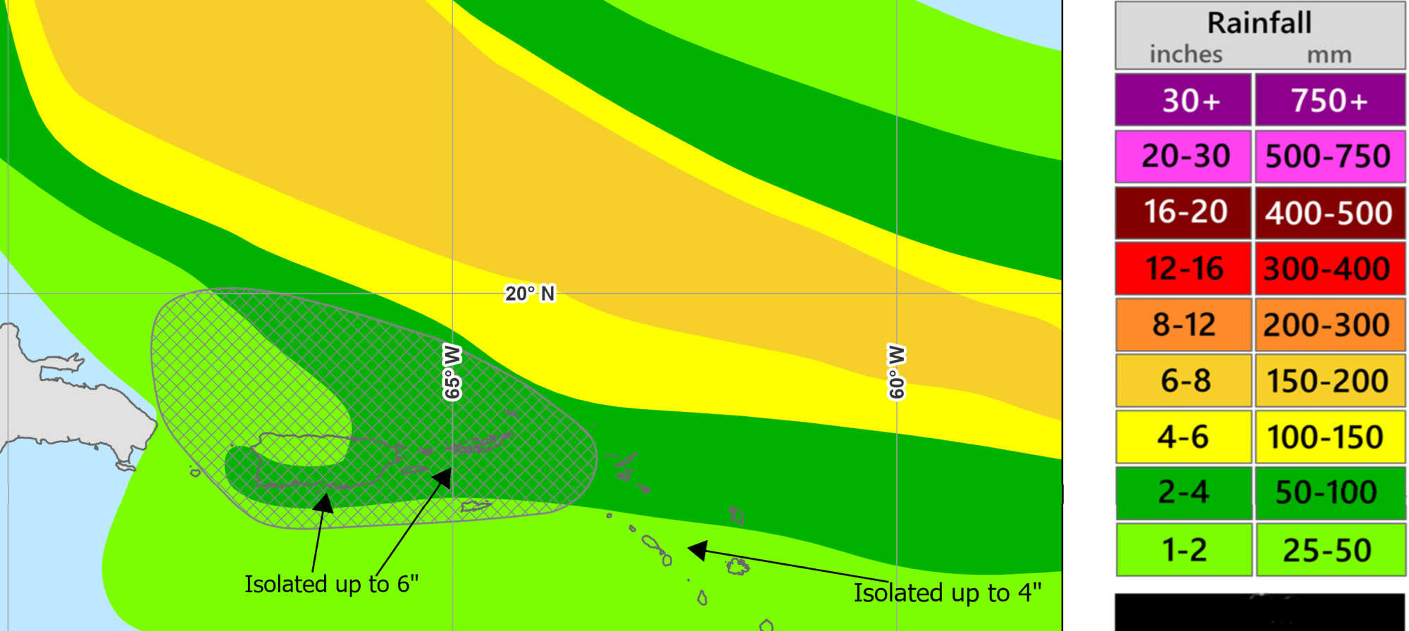
Forecast of rainfall from TS Erin through Aug. 19, with 2–4 inches expected across the USVI and northern Leeward Islands, isolated totals up to 6 inches, and 1–2 inches with isolated 4 inches for STX and parts of PR. Photo Credit: NOAA/WPC
Tropical Storm Erin strengthened on Thursday, with maximum sustained winds reaching 60 mph (50 kt) and minimum central pressure dropping to 998 mb, according to the National Hurricane Center’s (NHC) 5 p.m. AST (2100 UTC) advisory. The storm’s center was located near 16.7° N, 51.2° W—about 790 miles east of the northern Leeward Islands—and was moving west at 17 mph. A gradual shift to a west-northwest track is expected tonight into the weekend, bringing the core of Erin near or just north of the northern Leeward Islands.

For the first time this hurricane season, Tropical Storm Watches have been issued for parts of the northern Leeward Islands. The Meteorological Service of Antigua and Barbuda placed Anguilla and Barbuda under watch, France issued watches for St. Martin and St. Barthelemy, the Netherlands did the same for Saba and St. Eustatius, and St. Maarten’s meteorological service issued a watch for Sint Maarten. A tropical storm watch indicates that conditions are possible within 48 hours. The NHC cautions that additional watches for the U.S. Virgin Islands, British Virgin Islands, and Puerto Rico may be issued later tonight or Friday.
Forecast and Strengthening
The NHC projects Erin will reach hurricane status by Friday, potentially intensifying to 90 kt (105 mph) by Saturday night and 100 kt (115 mph) by Sunday evening, before gradually turning northwest early next week. Light to moderate easterly wind shear and rising sea surface temperatures are expected to support rapid intensification over the next 48 hours. European model guidance (ECMWF ensembles) generally agrees with the forecast, showing Erin recurving northwest and avoiding a direct landfall on the Virgin Islands or Puerto Rico; however, greater-than-normal uncertainty remains in the long-range track and strength.
V.I. Territorial Emergency Management Agency (VITEMA) Director Daryl Jaschen, speaking during a Thursday Government House press briefing, confirmed that Hurricane Hunter aircraft will be deployed Thursday night to gather detailed meteorological data from within the storm. “As the storm moves closer in, it gives them a good opportunity to cover those areas,” he said, noting Erin was within the 51° W range typically required for flights into the storm’s center.
Potential Impacts for the Virgin Islands and Puerto Rico
According to the NHC, rainfall from Erin could begin affecting the region Friday evening, continuing through the weekend. Forecast totals are 2–4 inches, with isolated amounts up to 6 inches possible across the northernmost Leeward Islands, the U.S. and British Virgin Islands, and southern and eastern Puerto Rico. Localized flash flooding, urban flooding, and landslides on steep terrain are possible. Director Jaschen said current estimates call for three to four inches on each of the main U.S. Virgin Islands, with dry soils potentially absorbing much of the water, but warned that saturation could lead to flash floods.
Tropical-storm-force winds extend 60 miles from Erin’s center. Jaschen estimated a 30 percent chance of such winds on St. Thomas and St. John early Saturday, with a 19 percent chance for St. Croix. East winds 15–20 mph today and Friday will likely shift north-northwest with gusts to 25 mph this weekend.
Marine hazards are expected to be significant. Jaschen warned that swells could reach 8–12 feet, producing life-threatening surf and rip currents. “Please reconsider going out into the ocean. It may look nice and calm, but underneath you’re going to have some strong rip currents,” he cautioned. The NHC has advised small craft operators to prepare for deteriorating sea conditions and for beachgoers to follow local surf advisories.
Prior to Erin’s arrival, a heat advisory remains in effect for much of the Virgin Islands and Puerto Rico, with early-morning temperatures in the low 80s, humidity over 80 percent, and heat indices near 100°F. Hazy skies from Saharan dust are expected to clear as Erin draws in more moisture.
Preparedness and Sandbag Distribution
VITEMA is urging residents to finalize hurricane preparations, secure loose outdoor items, clear drains, stock emergency supplies, and monitor official updates. Jaschen stressed that the ongoing sandbag distribution is the only one scheduled for the 2025 hurricane season. Each household is eligible for six free sandbags, though those awaiting delivery will not receive them before Erin’s approach due to weather timing. Deliveries are expected Monday or Tuesday, conditions permitting. Distribution for walk-up collection continues today, Friday, and Saturday at designated fire stations and Department of Public Works sites in both districts.
Outlook
-
Through Saturday: Erin moves west-northwest toward the northern Leeward Islands, with watches in effect for multiple islands. Heavy rains and gusty winds begin late Friday.
-
Saturday–Sunday: The storm passes near or just north of the northern Leeward Islands. Tropical storm conditions possible in the Virgin Islands and Puerto Rico, with 2–4 inches of rain, localized flooding, and hazardous surf. Erin could reach Category 2 strength by Sunday.
-
Early Next Week: Erin is expected to move northwest into the southwest Atlantic, though forecast confidence decreases. Regardless of track, dangerous surf and rip currents will likely affect Atlantic-facing beaches.

Residents are encouraged to sign up for the Alert VI system and stay informed through NHC advisories and local emergency management updates.


Advertisements


