


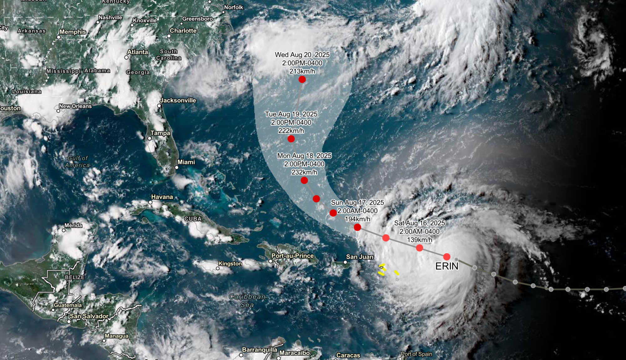
Hurricane Erin, the first hurricane of the 2025 Atlantic season, continues its west-northwest track toward the northern Leeward Islands, with the National Hurricane Center’s (NHC) 5:00 p.m. Friday advisory placing the storm about 365 miles east of the region. Maximum sustained winds have reached 75 mph, with the hurricane-force wind field extending 25 miles from the center and tropical-storm-force winds stretching out to 115 miles, primarily to the north.

Tropical Storm Watches remain in effect for Anguilla, Barbuda, St. Martin, St. Barthelemy, Saba, St. Eustatius, and Sint Maarten, signaling possible tropical-storm conditions within 48 hours. While no watches or warnings have been issued for the U.S. Virgin Islands or Puerto Rico, the NHC advises residents to monitor the storm’s progress closely.
The NHC expects Erin to maintain its west-northwest motion through Saturday before beginning a gradual turn north as a weakness develops in the subtropical ridge. Forecast models — including the European ECMWF ensemble — largely agree that Erin’s core will pass just north of the Leeward Islands, Virgin Islands, and Puerto Rico over the weekend. While dry Saharan air has been present, environmental conditions over 29–30°C waters are favorable for rapid intensification. Erin is projected to become a major hurricane by late Saturday, potentially reaching Category 4 strength (145 mph) by Monday.
Although a direct landfall is not expected, Erin’s size means its outer rainbands could bring periods of heavy rainfall, gusty winds, and dangerous marine conditions to the territory. The NHC warns that rainfall totals of 2–4 inches, with isolated amounts up to 6 inches, are possible from Friday night through Sunday across the northern Leeward Islands, the Virgin Islands, and Puerto Rico. Localized flash flooding, urban flooding, and landslides are possible, particularly in mountainous or poorly drained areas.
Swells generated by Erin will begin affecting the Virgin Islands and Puerto Rico Friday night, producing life-threatening surf and rip currents. Tropical-storm-force winds could reach the watch areas by early Saturday, with gusty rainbands possible across the U.S. Virgin Islands and Puerto Rico over the weekend.
During a Friday press briefing, Virgin Islands Territorial Emergency Management Agency (VITEMA) Director Daryl Jaschen reiterated the importance of readiness, noting that the height of hurricane season will continue for several months. He emphasized that although the storm’s forecast track remains north of the territory, residents should prepare for potential impacts from rainbands, swells, and wind gusts.
As of Friday, probability estimates for tropical-storm-force winds in St. Thomas and St. John have dropped from 30% to 20%, and for St. Croix from 19% to 12%. The chance of hurricane-force winds in the territory is near zero. Nonetheless, rainfall of 3–4 inches — with isolated totals up to 6 inches — is forecast across all three islands, from Friday night through Tuesday.
Marine hazards will also be significant. Ocean swells of 8–12 feet are expected, and the Coast Guard is implementing port condition changes: St. Thomas and St. John will move to Port Condition Yankee Friday night, while St. Croix will remain at Condition X-Ray until at least Saturday morning.
Jaschen reminded residents that Operation Blue Skies sandbag distribution, which began Thursday, is the only such event scheduled for the 2025 hurricane season. Distribution continues Friday at Department of Public Works sites and will conclude Saturday from 9:00 a.m. to 3:00 p.m. at designated fire stations: Cotton Valley and Grove Place on St. Croix, Fortuna, Tutu, and Omar Brown on St. Thomas, and Coral Bay on St. John.
Access and functional needs residents, along with seniors unable to leave their homes, have arranged for deliveries starting Monday and Tuesday to more than 80 households. VITEMA is coordinating the effort with the Department of Human Services and the Office of the ADA Coordinator.
Residents collecting sandbags should bring identification, a personal shovel if available, and plan for hot conditions by wearing light clothing, bringing water, and allowing time to fill up to six bags.

Jaschen urged all residents to sign up for VITEMA’s AlertVI system at www.vitema.vi.gov to receive notifications for hurricanes, flash floods, and other emergencies. “Be prepared, stay informed, and be vigilant,” he said, reminding the public that even as Erin moves away after Saturday night, lingering rainbands, rough seas, and rip currents could persist through Monday afternoon.


Advertisements


