


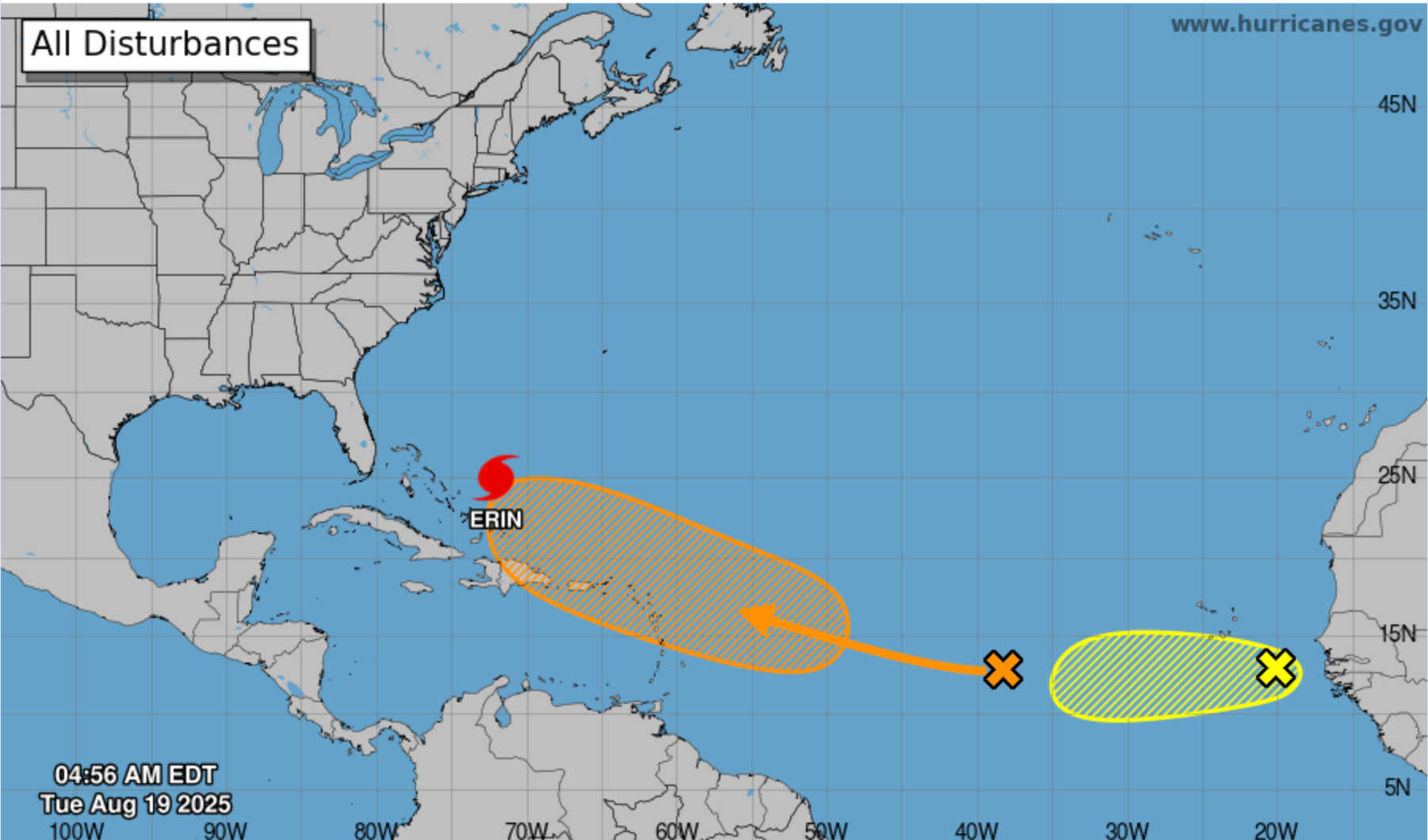
NHC's 7-day tropical weather outlook map from 4:56 AM on Tues., Aug. 19, 2025, showing Erin northwest of the Caribbean and two tropical disturbances—one approaching the Leeward Islands and another near Cabo Verde. Photo Credit: NHC.
The National Hurricane Center is monitoring two disturbances in the Atlantic—the first poised to approach the northern Leeward Islands later this week and the second near the Cabo Verde Islands—while Hurricane Erin, now a Category 3, heads away from the Caribbean.

The National Hurricane Center’s 2 AM EDT Tropical Weather Outlook identified two separate tropical waves in the Atlantic:
-
Central Atlantic Wave Near the Leeward Islands: A tropical wave over the central tropical Atlantic continues to produce a broad area of disorganized showers and thunderstorms. Environmental conditions appear conducive for gradual development, and the NHC notes a low (10 %) chance of formation through 48 hours and a medium (60 %) chance over seven days. The system is expected to move west to west‑northwest at about 20 mph, possibly approaching the Leeward Islands on Friday. European Centre for Medium‑Range Weather Forecasts (ECMWF) and GFS ensemble guidance generally show the disturbance organizing slowly as it nears the islands, though there remains considerable uncertainty in its strength. Residents of St. Thomas, St. John, St. Croix, Puerto Rico and the northern Leeward Islands should monitor forecasts and be prepared for potential increases in showers, gusty winds and higher seas by late week.
-
Eastern Atlantic Wave Near the Cabo Verde Islands: A second tropical wave located southeast of the Cabo Verde Islands is producing a concentrated area of showers and thunderstorms. Environmental conditions are generally favorable for additional development in the next couple of days as this wave moves west at about 15 mph. However, the NHC says the wave will likely encounter a less favorable environment later in the week, keeping development chances low—30 % through both 48 hours and seven days. Most ECMWF and GFS ensemble members keep this wave weak as it traverses the eastern and central Atlantic.
Model Consensus: Both ECMWF and GFS ensembles agree on a gradual development of the central Atlantic wave, with most members keeping it below hurricane strength as it approaches the Leeward Islands late this week. Some members show little development due to dry Saharan air, while others depict a modest tropical storm near the islands. The eastern Atlantic wave near the Cabo Verde Islands is depicted by most models as remaining a weak low as it traverses the eastern Atlantic, given the limited time in a favorable environment. Weather Underground’s tropical update pages, which mirror official NHC data, rate the central Atlantic wave as having a medium chance of formation and note that the second wave has a low probability of development at this time.
Hurricane Erin Update
At 5 AM EDT (0900 UTC), Hurricane Erin was located at latitude 24.8 °N, longitude 72.0 °W, about 675 miles southwest of Bermuda and 750 miles south‑southeast of Cape Hatteras, North Carolina. Erin has maximum sustained winds of 115 mph (185 km/h), making it a Category 3 hurricane, and is moving northwest at 7 mph. The NHC forecasts Erin to turn north‑northwest today, then north on Wednesday and northeast on Thursday, passing east of the Bahamas and moving between the U.S. East Coast and Bermuda. Although the storm’s winds have weakened slightly, Erin is predicted to grow substantially in size, with hurricane‑force winds extending 80 miles and tropical‑storm‑force winds reaching 205 miles from the center. Outer rainbands will continue to bring 1–3 inches of rain to the Turks and Caicos today and up to 3–8 inches across parts of the Bahamas, potentially causing flash flooding. Swells generated by Erin will produce life‑threatening surf and rip currents along the coasts of the Bahamas, Bermuda, the U.S. East Coast and Atlantic Canada during the next several days.
Local Outlook for the U.S. Virgin Islands & Puerto Rico (Tue–Thu)
The U.S. Virgin Islands and Puerto Rico are experiencing improving weather following Erin’s passage. Lingering moisture and weak southerly flow may still produce scattered showers and isolated thunderstorms today and Wednesday, but conditions should gradually return to more typical trade‑wind weather.
-
Tuesday: Partly to mostly sunny with isolated to scattered showers and a stray thunderstorm. Highs in the upper 80s to low 90s. South to southeast winds 10–15 mph.
-
Wednesday: Mostly sunny with only isolated showers. Highs again near 90–94 °F. Seas remain elevated due to residual swells from Erin; rip currents continue along north‑ and east‑facing beaches.
-
Thursday: Increasing cloudiness and showers possible late as the central Atlantic wave approaches. Prepare for higher rain chances and gusty winds late Thursday or Friday as the disturbance nears.


Advertisements


