


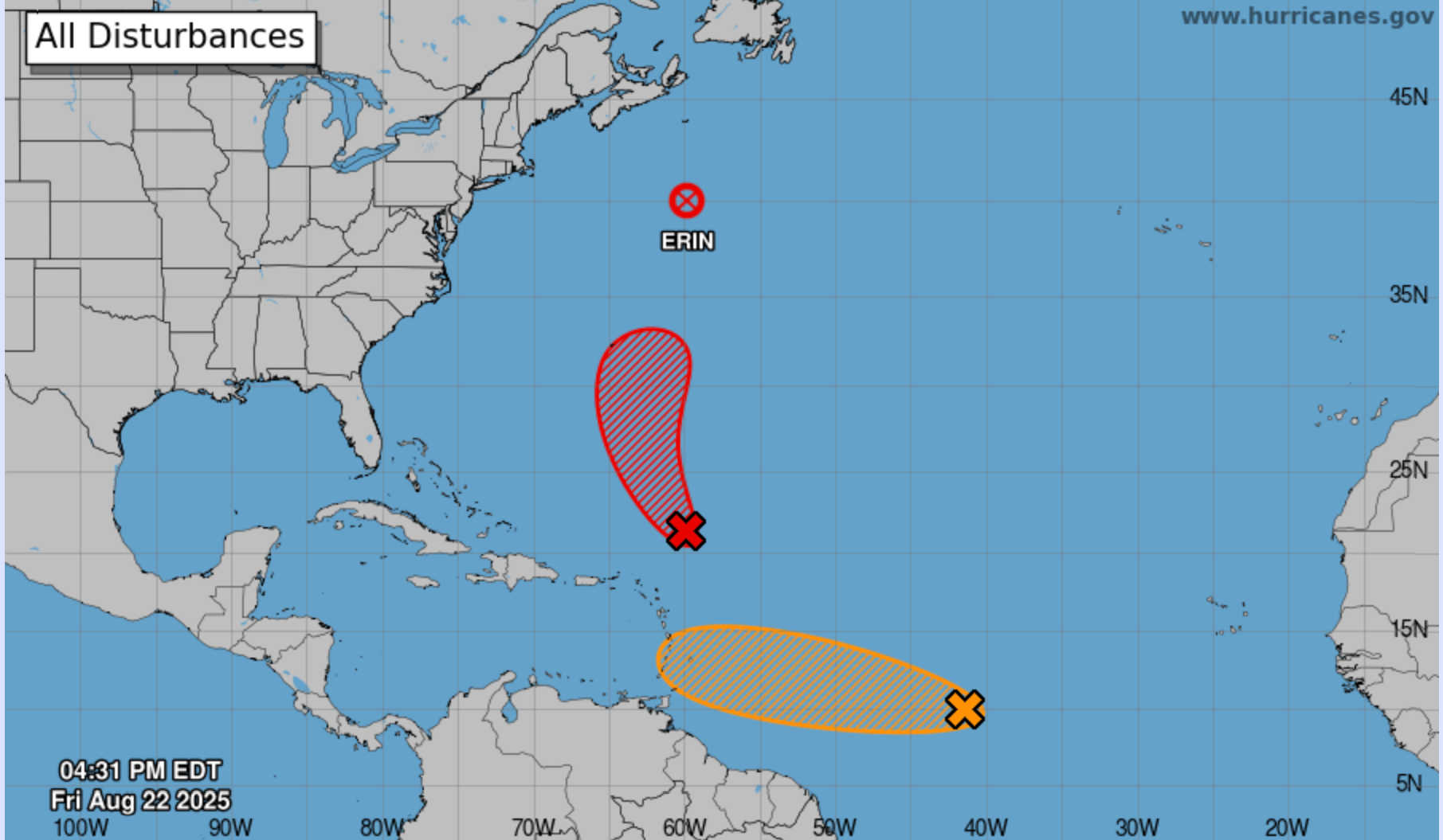
NHC map (Aug. 22, 2025) shows Post-Tropical Erin north of Bermuda, a system near the Leeward Islands with high formation odds, and another wave in the central Atlantic with medium chances. Photo Credit: NHC.
The Atlantic remained active on Friday evening, as the National Hurricane Center monitored two tropical disturbances alongside Post-Tropical Cyclone Erin, which continues to produce hazardous surf while racing across the north Atlantic.

Disturbance in the Central Tropical Atlantic (AL99)
A broad tropical wave designated AL99 is located roughly midway between Africa and the Windward Islands. Satellite data show well-organized showers and thunderstorms, though the system has yet to establish a closed circulation.
The NHC gives AL99 a 30 percent chance of development within 48 hours and a 40 percent chance over seven days. While conditions will turn less favorable through the weekend, they may improve early next week, raising the potential for the system to become a tropical depression.
Both ECMWF and GFS ensembles track the wave west-northwest at 10–15 mph across the central Atlantic. While most guidance suggests gradual development, a few model members bring the disturbance closer to the Lesser Antilles by late weekend or early next week. Given the uncertainty, residents of the Windward and Leeward Islands are urged to monitor updates, though significant impacts are not yet anticipated.
Disturbance Near the Leeward Islands (AL90)
Meanwhile, AL90, once considered a potential threat to the northern Leeward Islands, has swung sharply north and is no longer expected to impact Puerto Rico or the U.S. Virgin Islands.
The system, located about 250 miles northeast of the Leeward Islands, is continuing to organize in favorable conditions. The NHC assigns it an 80 percent chance of development within 48 hours and a 90 percent chance within seven days, with a tropical storm likely to form as it tracks northwest then north over the southwestern Atlantic.
Most model solutions keep the system well offshore, though some bring it closer to Bermuda, where tropical storm watches could be required this weekend.
Earlier Friday, Hurricane Erin completed its transition to a post-tropical cyclone. At 5 p.m. AST, Erin’s center was near 40.0° N, 59.7° W, about 605 miles north-northeast of Bermuda and 375 miles south-southeast of Halifax, Nova Scotia. The storm carried maximum sustained winds of 90 mph while racing east-northeast at 33 mph.
Though no longer tropical, Erin remains a large hurricane-force low with hurricane-force winds extending 125 miles from the center and tropical-storm-force winds reaching 435 miles outward. Gale-force gusts are possible across Nova Scotia and Newfoundland through Saturday.
The NHC cautioned that Erin’s circulation will continue to generate life-threatening surf and rip currents for the Bahamas, Bermuda, the U.S. East Coast, and Atlantic Canada into the weekend.
With AL90 tracking north and away from the region, the U.S. Virgin Islands and Puerto Rico face no direct threat. However, moisture on the southern edge of the system may still bring periods of showers and isolated thunderstorms through Saturday.
-
St. Thomas/St. John: Mostly cloudy with scattered showers and isolated thunderstorms; highs near 94°F with northeast winds of 15 mph and gusts up to 25 mph. Numerous showers expected Friday night with lows near 82°F.
-
St. Croix: Cloudy skies with scattered showers and highs near 94°F; east winds of 10–15 mph. Conditions remain unsettled into the evening with lows near 82°F.
-
San Juan: Partly cloudy in the morning, variably cloudy in the afternoon with scattered showers; highs near 89°F. Tonight brings numerous showers and isolated thunderstorms with lows near 82°F.
Marine conditions are forecast to remain choppy, with seas building due to AL90’s circulation and residual swells from Erin. Small craft advisories and rip current warnings remain in effect.
What to Watch
-
AL99: Medium development potential; may approach the Lesser Antilles early next week depending on environmental conditions.
-
AL90: Now curving north, unlikely to affect the Virgin Islands or Puerto Rico; Bermuda should prepare for possible watches.
-
Erin: Transitioned to post-tropical but still a large storm producing dangerous surf, rip currents, and gale-force gusts for Atlantic Canada.

The NHC will continue issuing updates at 2 a.m., 8 a.m., 2 p.m., and 8 p.m. EDT, with additional advisories as needed.


Advertisements


