


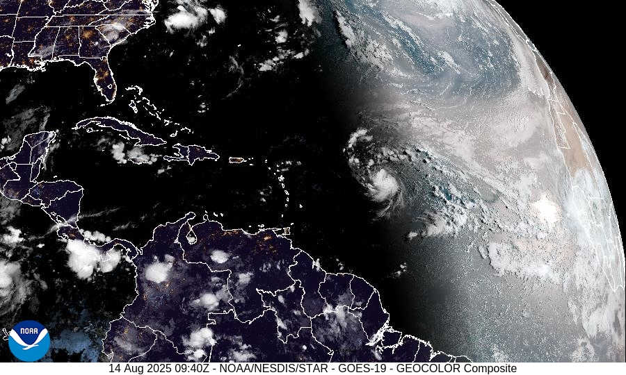
NOAA's Tropical Atlantic GeoColor satellite imagery.
The National Hurricane Center’s latest advisory (0900 UTC, August 14) places Tropical Storm Erin at latitude 16.3° N, longitude 48.2° W—about 990 mi (1 590 km) east of the northern Leeward Islands—moving west at 15 knots (17 mph). Maximum sustained winds are 45 kt (50 mph) with a minimum central pressure of 1002 mb. Weather Underground’s 9:00 UTC update echoes the same data: Erin’s winds are 50 mph, central pressure 1002 mb and it is moving west at 15 mph.

Forecast Track and Intensity
The NHC forecast advisory predicts Erin will continue westward today before bending west‑northwest tonight and through the weekend as a weakness develops in the subtropical ridge. Forecast positions show the storm moving from 16.8 N, 50.5 W by 1800 UTC today (50 kt winds) to 21.0 N, 64.1 W by 0600 UTC Sunday with 100 kt (115 mph) winds. Beyond Sunday, Erin is forecast to be near 23.2 N, 67.3 W on Monday and 26.0 N, 69.3 W on Tuesday with winds of 105–110 kt (120–125 mph). The NHC discussion notes that the environment—warm waters around 29 °C, decreasing wind shear and favorable upper‑level divergence—supports gradual strengthening followed by a period of rapid intensification over the next 24–48 hours. Erin is expected to become a major hurricane by Saturday.
The same discussion explains that the storm is currently steered by a subtropical ridge and will gradually turn west‑northwest tonight; early next week a weakness in the ridge should cause a northwest or north‑northwest turn. Guidance is tightly clustered through day 3, but there is larger spread beyond that; some models (GFS, Google DeepMind) track farther east while regional hurricane models are to the west. Key messages from the NHC emphasize that, although the core of Erin is likely to pass north of the northern Leeward Islands, locally heavy rainfall, high surf, rip currents and tropical‑storm‑force winds could affect the northern Leeward Islands, U.S. Virgin Islands and Puerto Rico this weekend. Residents are urged to monitor updates and prepare for dangerous surf and rip currents across the western Atlantic next week.
European Model Perspective
While the National Hurricane Center uses a blend of global models, its discussion points to guidance from the GFS and European (ECMWF) SHIPS models, which show decreasing wind shear and support rapid intensification. Ensemble members from the European Centre for Medium‑Range Weather Forecasts (ECMWF) generally keep Erin’s track north of the Leeward Islands and later curve it northwest toward the open Atlantic, consistent with the NHC’s consensus forecast. Some higher‑intensity solutions depict a more pronounced poleward turn, further reducing the risk of a direct impact on the Virgin Islands or Puerto Rico.
Local Impacts for the U.S. Virgin Islands and Puerto Rico
Rain and wind: The NWS San Juan forecast indicates hazy conditions this morning with scattered to numerous showers across St. Thomas, St. John and St. Croix. Highs reach around 94 °F, with east winds 15–20 mph and gusts up to 25 mph. Tonight, numerous showers with lows near 83 °F and gusty east winds are expected. Friday through the weekend, showers and isolated thunderstorms become more frequent—rain chances increase to 60–70 %—while winds gradually shift from east to north‑northwest as Erin passes north. Similar conditions are forecast for St. Croix: hazy, variably cloudy skies today with isolated to scattered showers; highs near 94 °F and rain chance 50 %, winds 15 mph. Saturday and Sunday bring numerous showers and isolated thunderstorms with highs around 94 °F and rain chances 70 %. For San Juan and vicinity, highs near 92 °F today with scattered showers (40 % chance). Rain chances climb to 60 % Friday and 70–80 % over the weekend with numerous showers and isolated thunderstorms.
Sea conditions and surf: The NHC warns that swells generated by Erin will reach the northern Leeward Islands, U.S. Virgin Islands and Puerto Rico by the weekend, causing life‑threatening surf and rip currents. Mariners should expect east winds 15–20 kt and seas 4–6 ft today, with conditions deteriorating as Erin intensifies. Small craft should exercise caution, and beachgoers are advised to heed local surf warnings.
Heat and humidity: Heat advisories remain in effect today for parts of the Virgin Islands and Puerto Rico. Morning lows around 82–83 °F and humidity near 80–84 % yield heat indices approaching 100 °F. Use sun protection and stay hydrated, particularly with hazy Saharan dust limiting visibility.
7‑Day Outlook

Through early next week, the outer effects of Erin will continue to bring showers and thunderstorms to the Virgin Islands and Puerto Rico. Rain chances remain elevated (50–70 %) Sunday through Tuesday, with winds gradually veering to the northwest and weakening as Erin moves away. Seas and surf will subside by mid‑week, but the risk of rip currents may persist. Temperatures stay warm in the upper 80s to mid‑90s each day with overnight lows in the low 80s. Later in the week, a return to typical trade‑wind–driven showers is expected.


Advertisements


