


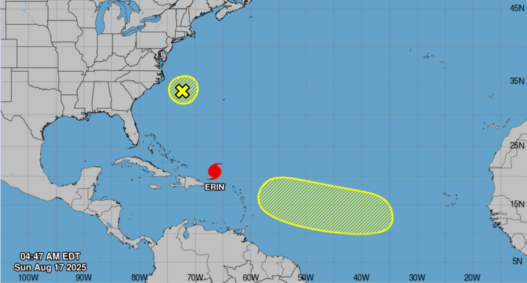
Graphical Tropical Weather Outlook issued by the NHC for August 17, 2025, at 5:00 a.m. AST, featuring satellite imagery and two-day development potential for tropical systems across the Atlantic basin. Photo Credit: NATIONAL HURRICANE CENTER.
Hurricane Erin, now a Category 3 storm in the Atlantic, is delivering heavy rain, strong winds, and dangerous surf to the U.S. Virgin Islands and Puerto Rico as it tracks west-northwest with a gradual turn to the north expected early in the week. At 5 AM AST, the center of Hurricane Erin was located at latitude 20.6°N and longitude 66.4°W, about 155 miles north of San Juan, Puerto Rico and 310 miles east of Grand Turk Island.

Erin is producing maximum sustained winds of 125 mph (205 km/h) and a central pressure of 940 mb. The storm is moving west‑northwest at 14 mph (22 km/h). Outer rainbands have been producing gusty winds and heavy rainfall across the U.S. Virgin Islands and Puerto Rico since Saturday night.
The National Hurricane Center (NHC) notes that Erin will slow today and begin turning north on Monday and Tuesday. Forecasts show the core of the hurricane passing east of the Turks and Caicos Islands and the southeastern Bahamas tonight and Monday. Hurricane‑force winds extend 25 miles from the center, while tropical‑storm‑force winds reach 205 miles. Rainfall totals of 3–6 inches, with isolated amounts up to 8 inches, are expected across the Virgin Islands and Puerto Rico, raising the risk of flash flooding and landslides.
The 0900 UTC NHC forecast advisory predicts that Erin will strengthen slightly today before gradually weakening later in the week. Forecast positions include 21.3 °N 67.9 °W with winds of 115 kt (130 mph) by Sunday evening, 22.5 °N 69.5 °W with 125 kt winds on Monday morning, and 23.8 °N 70.6 °W with 120 kt winds Monday evening. Beyond 72 hours, the hurricane should continue north‑northwest and eventually turn northeast as it encounters mid‑latitude westerlies; it is forecast to be near 33.3 °N 70.2 °W with 95 kt winds by late Wednesday.
Advisories and Hazards
-
Tropical Storm Warning for the Turks and Caicos Islands and Tropical Storm Watch for the southeast Bahamas. Tropical storm conditions are expected in the warning area tonight and possible in the watch area overnight into Monday.
-
Rainfall & Flooding: The outer bands will continue to produce heavy rain over the Virgin Islands and Puerto Rico today. Totals of 3–6 inches (isolated 8 inches) could lead to flash and urban flooding as well as landslides.
-
Wind: Squalls with tropical‑storm‑force gusts are possible across portions of the Virgin Islands, Puerto Rico and the central Bahamas today through Monday. Even if the center passes well north, outer rainbands can contain dangerous winds.
-
Surf: Swells generated by Erin will persist along the coasts of the Virgin Islands, Puerto Rico and Hispaniola, and will spread to the Bahamas, Bermuda, and the U.S. East Coast early this week. These swells are expected to produce life‑threatening surf and rip currents; beachgoers should heed local advisories.
St. Thomas and St. John
Rest of tonight: Cloudy with showers and scattered thunderstorms; windy with lows around 81 °F. Southwest winds 20–30 mph with gusts up to 40 mph; rain chance 90 %.
Sunday: Windy and cloudy. Showers and scattered thunderstorms in the morning followed by numerous showers with isolated thunderstorms in the afternoon. Highs around 90 °F. South winds 20–30 mph with gusts up to 45 mph; rain chance 80 %.
Sunday Night: Breezy; mostly cloudy with numerous showers and isolated thunderstorms. Lows around 82 °F; south winds 20–25 mph gusting to 30 mph; rain chance 60 %.
Monday: Breezy and mostly cloudy with scattered showers and isolated thunderstorms. Highs near 89 °F; south winds 15–20 mph gusting to 30 mph; rain chance 50 %. Conditions improve Monday night with fewer showers and decreasing winds.
St. Croix
Rest of tonight: Cloudy with showers and scattered thunderstorms; breezy with lows around 81 °F. Southwest winds 20–25 mph with gusts up to 35 mph; rain chance 80 %.
Sunday: Breezy and cloudy with numerous showers and isolated thunderstorms. Highs around 90 °F. South winds 15–25 mph with gusts up to 35 mph; rain chance 70 %.
Sunday Night: Breezy and mostly cloudy with numerous showers and isolated thunderstorms. Lows near 79 °F. South winds 15–20 mph gusting to 25 mph; rain chance 60 %.
Monday: Breezy; mostly cloudy with scattered showers and isolated thunderstorms. Highs around 90 °F; south winds 15–20 mph gusting to 25 mph; rain chance 50 %. By Tuesday the pattern transitions to partly cloudy skies with scattered showers and highs in the mid‑90s.
San Juan & Vicinity, Puerto Rico
Rest of tonight: Cloudy with showers and scattered thunderstorms. Lows around 81 °F; southwest winds 10–15 mph; rain chance 90 %.
Sunday: Cloudy with numerous showers and isolated thunderstorms. Highs around 90 °F; south winds 10–15 mph with gusts up to 25 mph; rain chance 70 %.
Sunday Night: Mostly cloudy with numerous showers and isolated thunderstorms. Lows around 81 °F; south winds 10–15 mph; rain chance 70 %.
Monday: Mostly cloudy with isolated thunderstorms; scattered showers in the morning and numerous showers in the afternoon. Highs near 91 °F; south winds 10–15 mph with gusts up to 20 mph; rain chance 60 %.
Tuesday: Partly cloudy in the morning, then mostly cloudy with numerous showers and isolated thunderstorms in the afternoon. Highs around 93 °F; rain chance 60 %. Conditions begin to improve mid‑week.
New Systems: Low Near North Carolina & Central Tropical Atlantic Wave
The NHC’s latest Tropical Weather Outlook lists two other areas of interest. An area of low pressure off the coast of North Carolina is producing disorganized showers and thunderstorms. Development is expected to be slow because the system is nearly stationary and will soon encounter unfavorable conditions; the NHC gives it a 10 % chance of formation through 48 hours and a 10 % chance through seven days.
Further east, the NHC notes that a tropical wave may develop into a low‑pressure system over the central tropical Atlantic during the middle to later part of the week. Some slow development is possible as it moves west‑to‑west‑northwest at 15–20 mph. The NHC assigns a near‑zero percent chance of development in the next two days and a 20 % chance over the next week. Ensemble guidance from the European Centre for Medium‑Range Weather Forecasts (ECMWF) and other global models largely agree that any system forming in this region will struggle to intensify due to dry air and strong upper‑level winds. Most model tracks keep the disturbance moving westward across the central Atlantic, but confidence is low on whether it will ever become a named storm.
Three‑Day Outlook (Sun–Tue)
-
Sunday: Expect widespread showers and isolated thunderstorms across St. Thomas, St. John, St. Croix and Puerto Rico as Hurricane Erin’s outer bands pass north of the islands. Winds will be strong and gusty from the south or southwest (20–30 mph with higher gusts), and seas will remain rough. Rainfall could lead to localized flooding and mudslides, particularly in mountainous areas. Residents should avoid flooded roadways, monitor warnings, and stay indoors during squalls.
-
Monday: As Erin begins to pull away to the north, winds will decrease slightly but remain breezy. Periods of scattered showers and isolated thunderstorms will continue, especially in the afternoon, with highs in the upper 80s to low 90s. Marine conditions remain hazardous.
-
Tuesday: A transition back toward typical trade‑wind weather begins. Expect scattered to numerous showers with improving sunshine; winds shift to the southeast and weaken. Temperatures warm to the low‑to‑mid 90s.


Advertisements


