

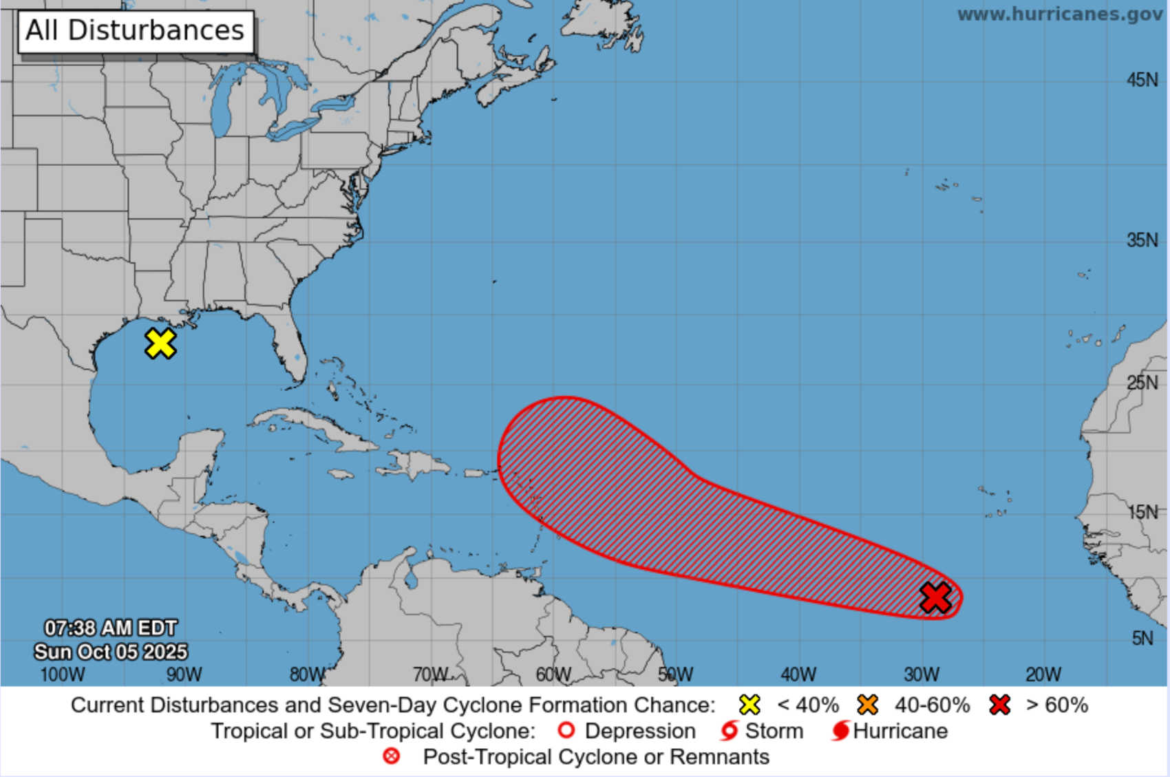
NHC map showing a broad low-pressure system south of the Cabo Verde Islands with a 70 percent chance of development over seven days as it moves west toward the Leeward Islands, including PR and the USVI. Photo Credit: NHC.
The National Hurricane Center (NHC) continues to monitor a broad area of low pressure south of the Cabo Verde Islands that could gradually strengthen as it moves across the Atlantic this week. As of the 2 a.m. EDT Sunday Tropical Weather Outlook, the NHC has raised development odds to 40 percent within 48 hours and 70 percent over seven days.

Forecasters say environmental conditions remain conducive for gradual development as the system travels west-northwestward across the central tropical Atlantic. The disturbance could reach the Leeward Islands — including the U.S. Virgin Islands and Puerto Rico — by the middle or latter part of this week.
While the system lacks a well-defined circulation, forecast models offer a wide range of potential outcomes. The National Weather Service (NWS) in San Juan noted that both the American GFS and European ECMWF models suggest an increase in moisture by Friday as the wave nears the region, though the exact track and intensity remain uncertain. Residents across the Leeward and Windward Islands are urged to monitor official forecasts and prepare for heavy rain, gusty winds, and localized flooding if the disturbance organizes.
Other Atlantic Activity
Elsewhere, a weak low-pressure system over the north-central Gulf of Mexico continues to produce scattered showers and thunderstorms, but strong upper-level winds should prevent development. The NHC maintains a near-zero percent chance of formation through the next week. According to Weather Underground, there are currently no named storms in the Atlantic basin.
Local Conditions in Puerto Rico and the U.S. Virgin Islands
The NWS San Juan’s early-morning forecast discussion highlights several ongoing hazards across the region, including dangerous surf, thunderstorms, and heat stress.
Coastal hazards: Long-period northerly swells continue to generate high surf, rip currents, and coastal flooding along north and east coasts of Puerto Rico, Culebra, Vieques, and St. Thomas. Waves of 14 to 18 feet may cause widespread beach erosion and flooding during high tides. Coastal Flood Warnings and High Surf Warnings remain in effect, and small-craft advisories are posted for the Atlantic waters.
Thunderstorms: Atmospheric moisture near 1.9 inches is fueling scattered showers and storms over the Virgin Islands and nearby waters. An upper-level low west of Puerto Rico will increase instability, producing additional afternoon convection over the island’s interior and western sectors as well as parts of the San Juan metro area. Passing showers and thunderstorms are also likely over the Virgin Islands and eastern Puerto Rico. Officials warn of urban and small-stream flooding, ponding on roadways, and dangerous lightning.
Heat stress: Temperatures will rise into the low- to mid-90s °F, and heat indices could exceed 102 °F, posing a risk for heat exhaustion among vulnerable populations without proper hydration or cooling.
Outlook for the Week
From Monday through Tuesday, a tropical wave will keep winds light and increase moisture, bringing periods of showers each day — most notably over interior and western Puerto Rico but also extending toward the San Juan area. The NWS assesses a medium flooding potential, mainly from urban and small-stream flooding, with isolated flash floods possible.
By Wednesday and Thursday, drier air behind a departing upper-level low should temporarily stabilize conditions. However, another disturbance late Thursday will bring renewed showers and isolated thunderstorms across the islands.
By Friday into the weekend, attention turns back to the broad tropical wave moving west from the eastern Atlantic. Its development — now given a 30 percent chance in 48 hours and 60 percent within seven days — will determine local impacts. Forecast models suggest increasing moisture across the eastern Caribbean by late week.
Marine Conditions
According to the NWS Coastal Waters Forecast, the long-period north-northwesterly swell continues to create rough marine conditions. Seas of 9 to 10 feet are expected today across the Atlantic waters off Puerto Rico and the U.S. Virgin Islands, with easterly winds of 5 to 10 knots. Seas are forecast to gradually subside to 7 to 8 feet by Monday, though scattered showers and isolated thunderstorms will persist. Mariners are urged to observe small-craft advisories and stay out of the water during storms.
Regional Impact Outlook
If the developing disturbance organizes, it could bring heavy rainfall, gusty winds, and rough seas to the northern Leeward Islands, including the U.S. Virgin Islands and Puerto Rico, during the second half of the week. The NHC and NWS emphasize that uncertainty remains high, as model trajectories differ widely. Regardless of development, the associated tropical wave will increase moisture and rain chances across the eastern Caribbean later this week.
Islands farther west — including Hispaniola, eastern Cuba, and Jamaica — face no immediate threat but should keep monitoring official updates. Eastern Caribbean islands closer to the system’s projected path, such as Guadeloupe, Antigua, and the northern Lesser Antilles, could experience torrential rain and localized flooding by late week.
Safety Reminders for Residents and Visitors
Stay informed: The disturbance has a moderate to high potential for development. Monitor official updates from the National Hurricane Center and local meteorological offices.
Avoid coastal waters: Dangerous surf up to 18 feet and rip currents make swimming and boating hazardous along northern and eastern coastlines.
Expect storms: Be prepared for heavy rain, localized flooding, and lightning through early in the week. If thunder roars, stay indoors.

Take heat precautions: Stay hydrated, limit outdoor activities during peak afternoon hours, and check on those sensitive to heat as indices exceed 102 °F.


Advertisements