




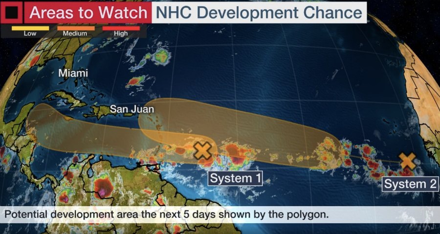
The National Hurricane Center is tracking two systems that are projected to develop into tropical depressions in the coming days, with the second system's current path taking it toward the Leeward Islands, including the USVI and Puerto Rico.

According to N.H.C., the second system, which was located over the far eastern tropical Atlantic well to the south-southeast of the Cabo Verde Islands at 2:00 a.m. Monday, has been producing a large area of cloudiness and disorganized showers.
"The wave is forecast to move westward to west-northwestward at 15 to 20 mph during the next few days, and environmental conditions are expected to become more conducive for the development of a tropical depression during the middle-to-latter part of this week while the system moves across the central tropical Atlantic," N.H.C. said.
It is a system interests in the Leeward Islands should pay close attention to.

N.H.C. gave the system a low chance of development in the next 48 hours at 10 percent, and a medium chance of development in the next five days of 60 percent.
Over the weekend, N.H.C. reminded that the peak of hurricane season — starting mid-August through late October — has begun and provided an important message to encourage preparedness.
"Preparedness is everything when you start thinking about the hurricane season," said Ken Graham, director of the National Oceanic and Atmospheric Administration's National Hurricane Center in Miami, Fla. "So think about those hazards that stretch well outside that center, well outside the cone."
Mr. Graham said historically water has killed the most people in tropical systems. "So storm surge and that rainfall inland, that's what we got to protect ourselves from."
He added, "Don't forget it's also about the wind and it's also about those tornadoes so knowing your risks, having a plan to mitigate those risks, that's how we stay together in Hurricane Season 2020."
The other system, which N.H.C. described as a fast-moving tropical wave located about 400 miles east of the Windward Islands, has been producing disorganized shower and thunderstorm activity.
"This disturbance is expected to move westward at about 20 mph during the next few days, and that fast forward speed is likely to limit significant development while the system approaches the Windward and southern Leeward Islands today, and moves across the eastern and central Caribbean Sea on Tuesday and Wednesday," N.H.C. said.
"After that time, however, the system is expected to move more slowly westward across the western Caribbean Sea, where upper-level winds could become more conducive for the development of a tropical depression during the latter part of this week.

"Regardless of development, locally heavy rainfall and gusty winds are expected over portions of the Windward and southern Leeward Islands beginning this evening through Tuesday morning," N.H.C. said.