




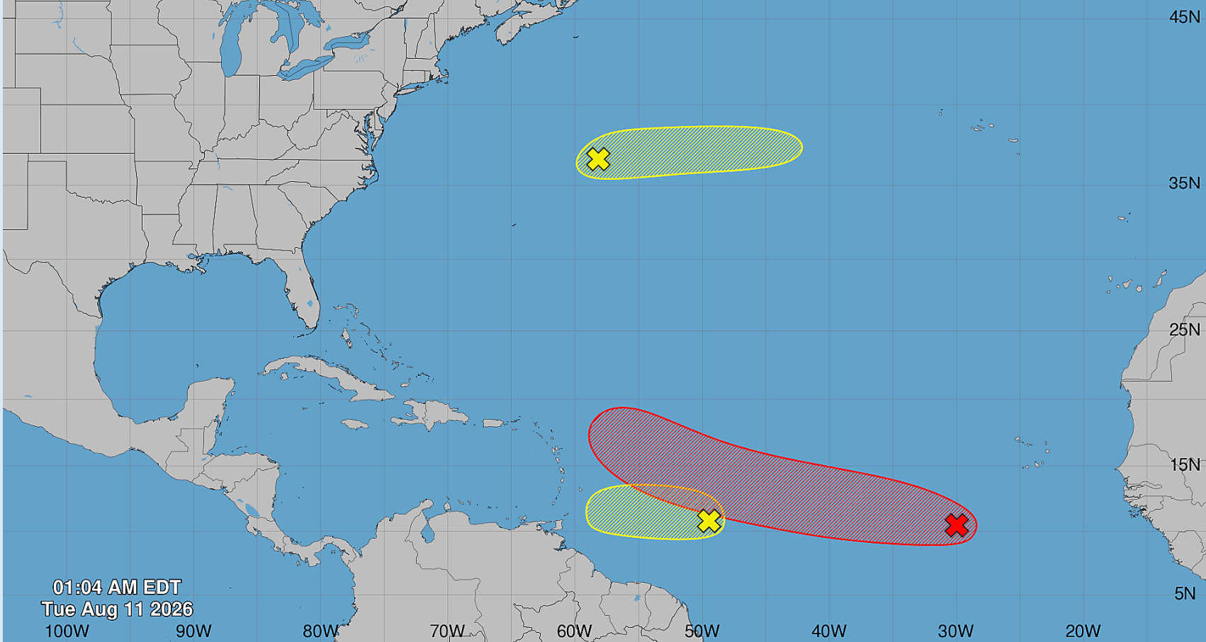
The National Hurricane Center is monitoring three disturbances across the Atlantic, led by an area of low pressure southwest of the Cabo Verde Islands that now has a 70 percent chance of developing within seven days, with a tropical depression considered likely during the latter half of this week.

In its 2 a.m. Tuesday Tropical Weather Outlook, the NHC said shower and thunderstorm activity associated with the system was currently limited. The area of low pressure was located about 500 miles southwest of the Cabo Verde Islands.
Environmental conditions are forecast to become progressively more favorable for development over the next day or two.
A tropical depression is likely to form during the latter half of the week as the system moves west to west-northwest across the central tropical Atlantic.

The disturbance has a 30 percent chance of formation within 48 hours and a 70 percent chance within seven days.
Wave East of Windward Islands Remains at 10 Percent
Closer to the Caribbean, the NHC is also tracking a tropical wave located approximately 850 miles east of the Windward Islands.
Disorganized showers and thunderstorms were associated with the wave early Tuesday, and some gradual development remains possible during the next day or two as the system moves quickly westward across the central tropical Atlantic.
Its development window, however, is expected to close as it approaches the islands.
The NHC expects the system to encounter a large area of dry environmental air by the time it reaches the Windward Islands Wednesday night, conditions that should end its chances for further development.
The wave has a 10 percent chance of formation through 48 hours and a 10 percent chance through seven days.
Third Disturbance Northeast of Bermuda
A third system is being monitored in the central subtropical Atlantic.
A trough of low pressure located several hundred miles northeast of Bermuda is producing disorganized showers and thunderstorms.
Some development is possible over the next couple of days as the disturbance moves eastward at approximately 20 mph across the central subtropical Atlantic.
However, the system is forecast to reach cooler waters later this week, which is expected to end its chances of development by Thursday.
The disturbance carries a 10 percent chance of formation through 48 hours and seven days.

The NHC’s Tuesday morning outlook covers the North Atlantic, Caribbean Sea and Gulf of America.