


The Tropical Atlantic at 5:00 a.m. Wed. Sept. 21, 2022. Photo Credit: NOAA
While there are currently several weather systems churning in the Atlantic, with a total of five — including Cat. 4 Hurricane Fiona and Tropical Storm Gatson — being tracked by the National Hurricane Center, none of these systems currently pose a threat to the U.S. Virgin Islands, according to N.H.C. tracking data.

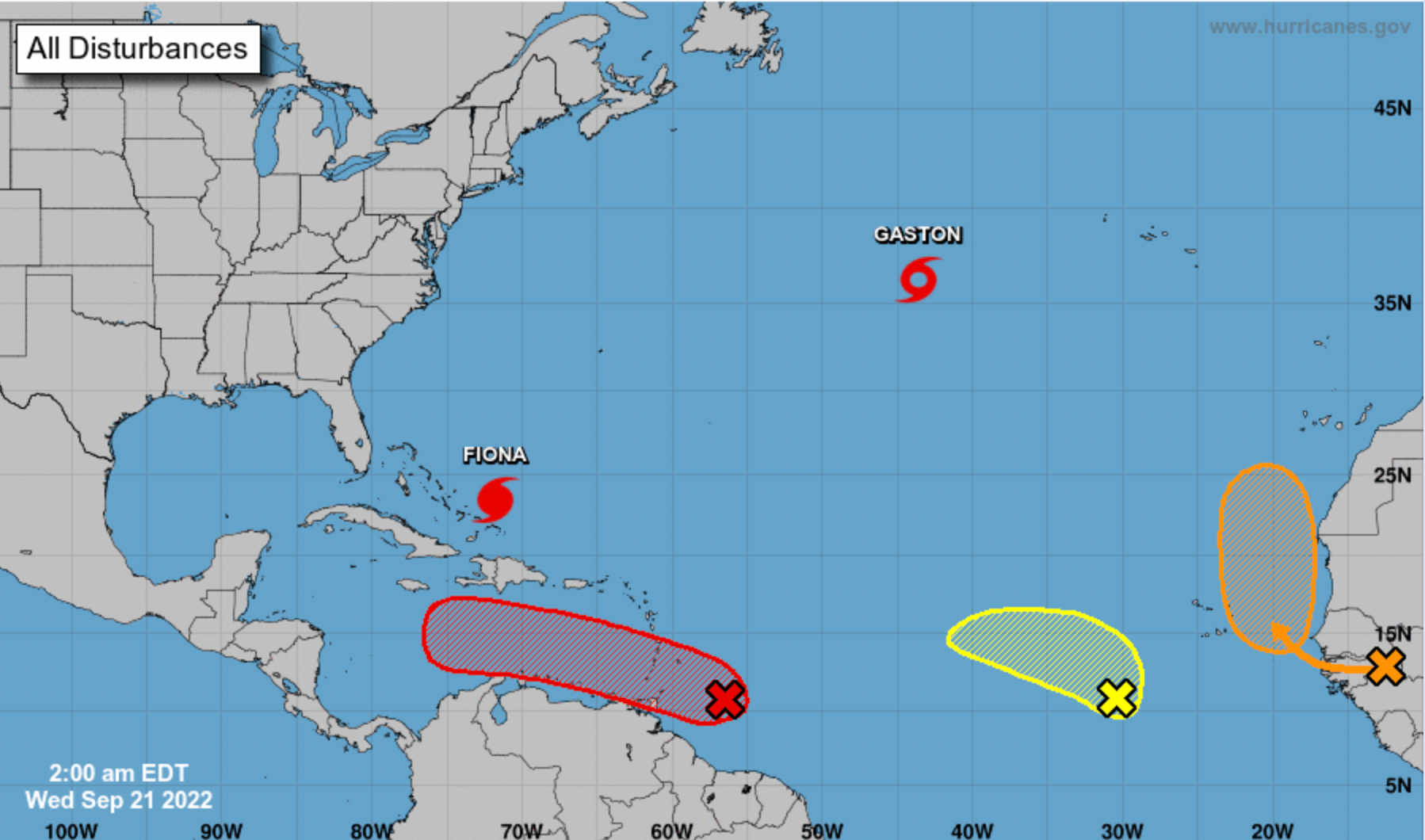
Hurricane Fiona
On the forecast track at about 2:00 a.m. Wednesday, the center of Fiona continued to move away from the Turks and Caicos and will approach Bermuda late on Thursday.
Reports from an Air Force Reserve Hurricane Hunter aircraft indicate that the maximum sustained winds are now near 130 mph (210 km/h) with higher gusts. Additional strengthening is forecast through tonight. Some fluctuations in intensity are possible tonight and Thursday.
Tropical Storm Gatson
At 3:00 a.m. Wednesday the center of Tropical Storm Gaston was located near latitude 36.2 North, longitude 43.6 West. Gaston is moving toward the north-northeast near 18 mph (30 km/h). A turn to the northeast is expected today, followed by a motion toward the east starting Thursday. N.H.C. says interests in the Azores should monitor Gatson's progress.
New Disturbances
Western Tropical Atlantic
A tropical wave is producing shower and thunderstorm activity a few hundred miles east of the southern Windward Islands. The system continues to show signs of organization and it will likely become a tropical depression within the next two or three days. The disturbance is forecast to move west-northwestward across the southern Windward Islands by late today and then move toward the central Caribbean Sea later this week. Interests in the Windward Islands should closely monitor the progress of this system as heavy rainfall and gusty winds could affect these islands beginning later today.
Formation chance through 48 hours is high at 70 percent. Formation chance through 5 days is high at 90 percent.
Eastern Tropical Atlantic
A tropical wave is forecast to move off the west coast of Africa on Thursday. Environmental conditions are forecast to be conducive for at least gradual development of the system for a couple days thereafter while the system moves slowly northward, between west Africa and the Cabo Verde Islands, through the end of the week.
Formation chance through 48 hours is low at 10 percent. Formation chance through 5 days is medium at 50 percent.
East Central Tropical Atlantic
A tropical wave located several hundred miles west-southwest of the Cabo Verde Islands is producing disorganized shower activity. Slow development of this system is possible over the next several days as it moves northwestward and then westward over the tropical Atlantic.

Formation chance through 48 hours is low at 0 percent. Formation chance through 5 days is low at 20 percent.


Advertisements


