




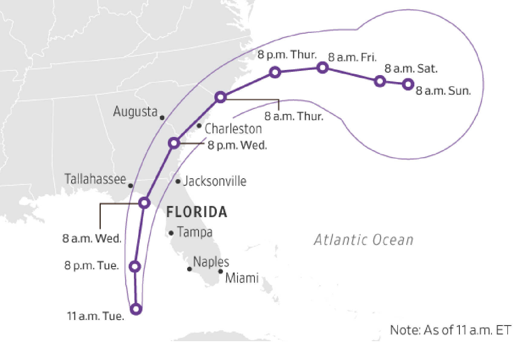
Hurricane Idalia has intensified into a Category 2 storm and is set to unleash potentially catastrophic conditions along Florida's Gulf Coast tonight and Wednesday, according to the National Hurricane Center (NHC). Packing maximum sustained winds of 100 mph, the storm is located about 195 miles southwest of Tampa and 300 miles south of Tallahassee as of 5 p.m. EDT.

A Hurricane Warning is in effect from the middle of Longboat Key northward to Indian Pass, including Tampa Bay. The NHC has also issued a Storm Surge Warning for areas from Englewood northward to Indian Pass, with life-threatening storm surges expected to flood normally dry areas near the coastline.
In addition to Florida, several watches and warnings have been extended to parts of North and South Carolina. Notably, a Hurricane Watch has been issued from the mouth of the St. Mary's River northward to Edisto Beach, South Carolina.
"The combination of a dangerous storm surge and the tide will cause normally dry areas near the coast to be flooded by rising waters moving inland from the shoreline," warns the NHC. Peak storm surge could range from 10-15 feet in certain areas, notably from Aucilla River to Yankeetown in Florida.

Meteorologists also warn of wind hazards, stating that, "Hurricane conditions are expected within the hurricane warning area in Florida by tonight or early Wednesday." The winds extend outward up to 25 miles from the storm's center, and tropical-storm-force winds extend outward up to 160 miles.
Local authorities are urging residents to finalize their preparations to protect life and property. Evacuation orders have been issued in various counties, and emergency shelters are being set up for residents who are unable to evacuate to safer locations.
Idalia is moving north at 16 mph and is expected to reach Florida's Big Bend coast on Wednesday morning. It will likely then veer northeast, skimming the coasts of Georgia, South Carolina, and North Carolina late Wednesday and Thursday. According to reconnaissance data, the minimum central pressure of the storm is 972 mb (28.71 inches).
Rainfall and Tornado Risks
Western Cuba and parts of Florida's west coast, the Panhandle, and southeastern states could receive 4 to 8 inches of rain, with isolated totals up to 12 inches. Flash and urban flooding are also expected. Furthermore, a few tornadoes are possible along the west-central Florida coast tonight, extending northward to southeast Georgia and the coastal Carolinas on Wednesday.
Residents are advised to monitor local news and the National Weather Service for the most current information and to follow all evacuation and safety instructions from local officials.

For storm-specific information, please visit hurricanes.gov or consult your local National Weather Service forecast office.