

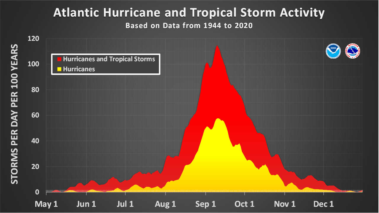
The Atlantic hurricane season is approaching what historically is its most active point of the year with an unusually quiet record: five named storms, no hurricanes, no major hurricanes and overall tropical cyclone activity running 91 percent below normal.

As of early Monday, the National Hurricane Center listed five named storms for the 2026 Atlantic season — Arthur, Bertha, Cristobal, Dolly and Edouard. None reached hurricane strength. By Sept. 7, the 1991–2020 climatological average would be approximately seven named storms, three hurricanes and one major hurricane.
The difference is even more striking when measured through Accumulated Cyclone Energy, or ACE, an index that accounts for both the strength and duration of tropical storms and hurricanes.
The Atlantic’s ACE stood at just 4.4 as of Sept. 7 — 91 percent below the normal amount accumulated by this point in the season, according to NHC.

And there is little indication of an immediate change.
In its 2 a.m. Monday Tropical Weather Outlook, the National Hurricane Center said tropical cyclone formation is not expected anywhere in the North Atlantic, Caribbean Sea or Gulf during the next seven days.
If that forecast holds, the basin would pass Sept. 10 — the climatological peak of Atlantic hurricane season — without producing a hurricane.
Five Storms, None Reached Hurricane Strength
The season began with Tropical Storm Arthur, which formed June 17 and reached maximum sustained winds of 40 knots, or about 46 mph.
Bertha followed in July and became the strongest storm of the season to that point, reaching 50 knots, or approximately 58 mph. Cristobal formed in August and peaked at 40 knots, followed by weak Tropical Storm Dolly late in the month.
Edouard became the fifth named storm on Aug. 31 and also reached 50 knots before dissipating Sept. 2.
A hurricane requires sustained winds of at least 64 knots, or 74 mph. None of the five storms has approached that threshold closely enough to reach hurricane classification.
NHC’s current seasonal accounting therefore shows the Atlantic two named storms behind normal, three hurricanes behind normal and one major hurricane behind normal for this point in the calendar.
ACE magnifies that difference because short-lived and relatively weak tropical storms contribute far less energy to the seasonal total than long-lived hurricanes.
NHC calculates ACE by taking the square of a named storm’s maximum sustained wind speed every six hours while the system remains at least tropical-storm strength, then adding those values over time. A powerful hurricane persisting for days can therefore generate far more ACE than several brief tropical storms combined.
NOAA Had Already Lowered Expectations for 2026
The slow season is broadly consistent with NOAA’s revised outlook issued Aug. 6, although activity to date has been even weaker than the lower-end hurricane numbers envisioned in that forecast.
NOAA increased its probability of a below-normal Atlantic season to 75 percent, with a 20 percent chance of near-normal activity and only a 5 percent chance of an above-normal season.
The revised forecast called for seven to 13 named storms, two to six hurricanes and zero to two major hurricanes over the full season. NOAA also projected seasonal ACE at between 30 and 90 percent of the historical median.
Five named storms have now formed, but the Atlantic would still need at least two hurricanes during the remainder of the season to reach the bottom of NOAA’s projected hurricane range.
That remains entirely possible. NOAA’s forecast covers the full season through Nov. 30, and the agency specifically cautions that seasonal outlooks do not predict where or whether individual hurricanes will make landfall.
El Nino Is Suppressing Atlantic Development
One of the principal factors behind the expected slowdown is El Niño.
NOAA said in its August update that El Niño was strengthening and expected to persist through the heart of hurricane season. Strong El Niño conditions typically increase upper-level winds across portions of the tropical Atlantic, producing vertical wind shear that can disrupt developing tropical systems.
NOAA also pointed to stronger-than-normal trade winds across portions of the Atlantic’s Main Development Region and a West African monsoon pattern that has been less favorable for tropical cyclone formation.
The agency said every Atlantic hurricane season since 1950 coinciding with a strong El Niño during the peak months has produced below-normal overall activity.
That does not mean tropical Atlantic waters are unusually cold. NOAA said sea-surface temperatures across the Main Development Region remain somewhat above average, but the warmth has been insufficient to overcome the atmospheric conditions suppressing storm organization.
Sept. 10 Is the Peak, Not the End
For the Virgin Islands and wider Caribbean, the quiet conditions carry an important qualification.
The National Hurricane Center identifies Sept. 10 as the climatological peak of Atlantic hurricane season, but says most tropical cyclone activity historically occurs from mid-August through mid-October. The official season continues through Nov. 30.
Virgin Islanders have experienced firsthand why a quiet start or passage of the statistical peak cannot be treated as an all-clear.
Hurricane Irma passed through the northern Virgin Islands on Sept. 6, 2017, as a Category 5 hurricane with maximum sustained winds of 185 mph. At 5 p.m. that day, its eye was approximately 40 miles northwest of St. Thomas.
Less than two weeks later, on Sept. 19, Category 5 Hurricane Maria approached St. Croix with sustained winds of approximately 165 to 175 mph as its rainbands and destructive conditions spread into the territory.
Those storms demonstrate that some of the territory’s greatest hurricane danger historically has occurred precisely during the period the Atlantic is now entering.
Seven Quiet Days Ahead for Now
For the immediate future, however, the Atlantic remains exceptionally quiet.
As of Monday morning there were no active tropical cyclones anywhere in the Atlantic basin, and NHC was monitoring no disturbance with a chance of development during the coming week.

If that outlook remains unchanged, the Atlantic would reach and move beyond its Sept. 10 climatological peak without a hurricane and with seasonal energy still dramatically below normal.