

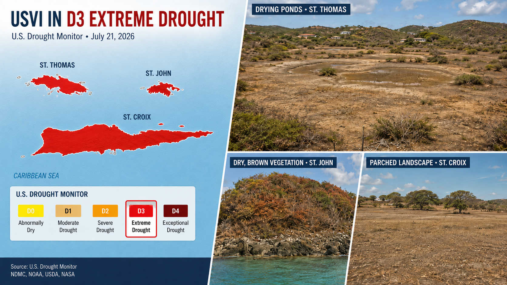
St. Croix, St. Thomas and St. John are now classified as being in Extreme Drought, following record or near-record warmth and dryness that has depleted ponds, stressed vegetation, increased agricultural costs and left insufficient water for some residents to fill their cisterns.

Both Henry E. Rohlsen Airport on St. Croix and Cyril E. King Airport on St. Thomas recorded their driest June on record. The May-through-July period was also the second driest across the islands since recordkeeping began in the early 1950s.
The regional drought update, based on information available as of 5 p.m. Atlantic time on July 21, also warns that conditions are likely to persist or expand through early fall. Forecast models show a greater than 70 percent chance of below-normal rainfall and above-normal temperatures across Puerto Rico and the Virgin Islands from August through October.
Region Dried Rapidly After Wetter Start to Year

The U.S. Caribbean experienced wetter-than-normal conditions during late winter and early spring, but rainfall declined significantly during May, June and July.
Near-record warmth and dryness have since contributed to grass fires, critically low stream levels and declining water supplies in reservoirs and underground wells. The conditions are also producing economic losses across the agricultural sector.
Puerto Rico has imposed water rationing for agricultural users in its south-central and southwestern regions and for residents in portions of the northeast.
The summary accompanying the update cited more than 300 brush-fire reports in Puerto Rico during July alone. The fires were described as unusually intense and expansive, with rare damage to local infrastructure.
Soils have continued to dry, while vegetation stress remains particularly severe along Puerto Rico’s southern coast.
Entire USVI Classified in D3 Drought
The July 21 U.S. Drought Monitor placed the entire Virgin Islands in Extreme Drought, or D3.
In Puerto Rico, Severe Drought, or D2, extends across the southern plains from Cabo Rojo to Cidra. Moderate Drought, or D1, covers much of the eastern and southern half of the island, while Abnormally Dry conditions, classified as D0, are present in the north-central and northwestern regions.
Parts of western Puerto Rico remain outside the drought and abnormal-dryness classifications because localized rainfall helped reduce the severity of conditions there.
The U.S. Drought Monitor uses five classifications. D0 identifies areas that may be entering or emerging from drought, while D1 through D4 represent increasing levels of drought severity. The map is updated each Thursday using information from the National Drought Mitigation Center, NOAA, the U.S. Department of Agriculture and NASA.
Rainfall Deficits Widespread
Most of Puerto Rico received less than 60 percent of its normal rainfall during the 60 days leading up to the update.
Southern and southwestern areas received less than 20 percent of their typical precipitation, leaving rainfall deficits of between three and six inches.
The El Yunque rainforest area recorded deficits ranging from eight to 14 inches below average.
San Juan was experiencing its driest July on record and its fourth warmest. Juncos was experiencing its second driest and second warmest July on record.
A NOAA rainfall-departure map valid July 20 showed precipitation well below normal across most of Puerto Rico, with only a small part of the west reporting above-normal rainfall. Yellow, orange and red areas represented below-normal totals, while green, blue and purple indicated wetter-than-normal conditions.
St. Thomas Farmers Face Water and Feed Shortages
Across the Virgin Islands, high winds and limited rainfall are causing severe soil cracking and visible vegetation stress.
Farmers described the conditions as unusually harsh as ponds continued to lose water. Delays in obtaining irrigation supplies because of tariffs were also adding to the strain on agricultural operations.
On St. Thomas, livestock and poultry farmers are reporting reduced access to feed as Guinea grass dies.
Groundwater levels have shown little improvement, and water for agricultural use remains limited despite the delivery of 2,000 gallons by water truck to fill the fairgrounds cistern.
A photograph included in the update showed ponds drying at Greenridge Guavaberry Farm on St. Thomas. The image was taken by Royce Creque on July 21.
St. Croix Farmers Cut Costs and Cull Herds
Limited rainfall on St. Croix has depleted agricultural ponds and increased production costs.
Farmers are attempting to reduce their exposure by preparing land, installing or repairing fencing and developing irrigation systems.
Livestock producers are rotating animals and reducing herd sizes through culling.
Poultry farmers reported that the high cost of water and feed is reducing profits. Some have temporarily stopped purchasing new chicks until temperatures fall and natural grasses return.
A photograph taken by Mike Morgan on July 22 showed vegetation stressed by warm and windy conditions on Lang’s Peak.
Erosion and Crop Concerns on St. John
Farmers on St. John are preparing land for future crops while monitoring banana plants for signs of fungus.
Continuing erosion has made some roads impassable.
A photograph taken by Rafe Boulon on July 22 showed dry vegetation at Trunk Bay following intermittent rainfall and windy conditions.
The dry soils and lack of precipitation have affected specialty farmers, row-crop producers and fruit-tree growers throughout the Virgin Islands.
Vegetation is showing clear signs of stress, while rainfall and other available water supplies have been insufficient in some areas for residents to fill household cisterns.
Groundwater levels are also falling across both Puerto Rico and the Virgin Islands.
Puerto Rico Farmers Report Widespread Crop Stress
Agricultural damage is being reported throughout Puerto Rico.
In Canóvanas, farmers described record dryness and cracked soils. Breadfruit and avocado trees were dropping fruit prematurely, some avocados showed signs of dehydration, cacao leaves were turning yellow and young banana plants were wilting because of prolonged water stress.
Across the central interior, the combination of limited rainfall, dry conditions and high temperatures caused extensive soil cracking and affected crop growth and plant health.
In Cayey, breadfruit and rose apple trees were losing leaves, while other trees remained stressed despite producing blooms. Pasture growth had been stalled for approximately one month, leaving some grazing areas completely dry.
Orocovis farmers reported below-normal citrus production and pest infestations affecting mandarin trees.
In Caguas, prolonged dryness and high temperatures delayed crop development and affected leafy vegetables, including lettuce. Some farmers were hauling water to prevent further losses.
Aguas Buenas producers reported widespread soil cracking and unusually thin plantains. Farmers were allowing weeds to remain in place to conserve moisture, although the soils were failing to retain water even after rainfall. A wildfire also occurred near agricultural land.
Streams in Gurabo have dried completely or experienced significant reductions in flow.
In Lares, rainfall has been sufficient to wet only the soil surface. New plantings have been severely affected, while young trees are failing or dying, resulting in losses of plant stock and labor.
Pastures are drying across southern Puerto Rico, with burned grass reported in Juana Díaz, Salinas and Santa Isabel.
Reduced flow in the Río Grande de Loíza between San Lorenzo and Patillas has widened the river channel.
Plantain crops in Juana Díaz remain stressed but are surviving because of irrigation.
In the south and southwest, the severity of the drought has exceeded what farmers expected for the normally dry period. Pasture production, crop growth and reservoir levels have all been affected, causing economic losses.
Reservoir levels across the southern irrigation systems continue to decline.
Agricultural water rationing is in effect across the southern districts and is most severe in the southwest. Farmers in the Southwest District are receiving water three days each week.
In the Juana Díaz District, water flow has been reduced by approximately 5 percent as Lago Guayabal continues to lose water.
Streams serving the Patillas District are contributing only 25 percent of their normal flow.
Coffee beans are ripening prematurely, affecting their quality and flavor.
Ranchers in Lajas are facing forage shortages, increasing their reliance on supplemental feed and reducing available hay reserves.
Forests in Sierra Bermeja are experiencing defoliation and soil cracks between one and two inches deep.
Rivers, Wells and Soil Continue to Decline
Rivers and reservoirs across Puerto Rico are declining because of reduced recharge, while high temperatures and low soil moisture are increasing evaporation.
Several reservoirs have reached observational levels.
Groundwater is falling throughout Puerto Rico and the Virgin Islands. The U.S. Geological Survey has reported that numerous wells in southern and southeastern Puerto Rico have reached operational-adjustment or critical levels.
Puerto Rico Agricultural Water Management reported critically low root-zone soil saturation across the southern and northern plains and the western interior. Only isolated pockets of moisture remained following localized rainfall.
A streamflow map valid July 22 showed one-day average flows ranging from below normal to far below normal across much of Puerto Rico. Only a limited number of streams in the south and interior remained near normal.
The map used red and orange to indicate below-normal streamflow, green for near-normal levels and blue or black for above-normal conditions. The information was taken from the USGS river-gauge network and published through Drought.gov.
A separate soil-moisture assessment showed mostly dry root zones across the southern and northern plains and the eastern interior. Wetter areas were confined primarily to portions of the west, western interior and small sections of the eastern coast.
Fire Risk Remains Elevated
The dry vegetation and low soil moisture have sharply increased the danger of wildfires.
The update’s detailed impact section reported nearly 300 wildfire incidents during the period examined, concentrated primarily in Puerto Rico’s southern and eastern municipalities.
That followed the summary’s report of more than 300 brush fires in July alone.
Hotter and Drier Conditions Favored Through October
The North American Multi-Model Ensemble favors below-normal precipitation and above-normal temperatures across Puerto Rico and the Virgin Islands during the next three months.
A strengthening El Niño in the Pacific is expected to reduce the frequency of tropical waves and cyclones reaching the region.
That reduction in tropical activity could worsen existing rainfall deficits and allow the drought to persist or intensify, consistent with NOAA’s seasonal drought outlook.
Drought is expected to continue across the Virgin Islands and southern and southeastern Puerto Rico through the fall. It is also forecast to develop across the remainder of Puerto Rico.

Farmers and other residents may report drought impacts through the Drought Condition Monitoring Observations and Reports tool or through the Caribbean Climate Hub’s reporting group on WhatsApp.