


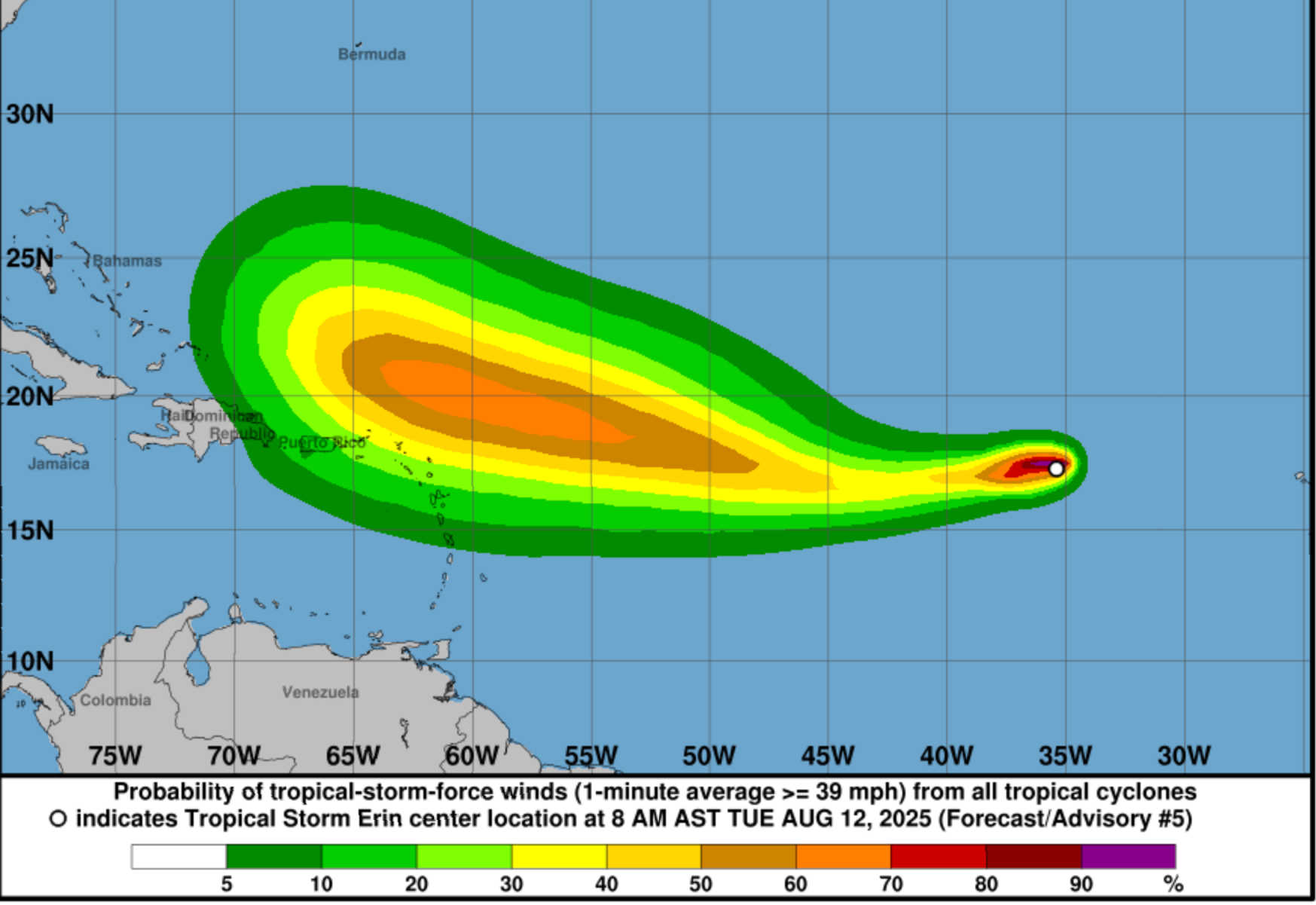
Tropical Storm Erin is gaining strength in the central Atlantic and could become the first hurricane of the 2025 Atlantic season by Thursday, according to the National Hurricane Center. At 11 AM AST (1500 UTC) on Tuesday, August 12, Erin’s center was located near 17.2 °N, 36.3 °W, about 1,765 miles east of the northern Leeward Islands. The storm was moving west at 23 mph with maximum sustained winds of 45 mph and a minimum central pressure of 1006 mb. No coastal watches or warnings were in effect, but the NHC advised residents of the northern Leeward Islands, U.S. Virgin Islands and Puerto Rico to monitor the storm’s progress.

Erin formed from an area of low pressure that emerged off West Africa earlier this week. Forecast models agree it will strengthen into a hurricane by late Thursday or early Friday, with the National Hurricane Center’s forecast calling for gradual intensification and winds reaching Category 3 strength by Saturday. European ensemble models (ECMWF) and U.S. GFS ensembles show strong consensus that the storm will curve north-northeast next week as it encounters an upper‑level trough, keeping the core east of the U.S. mainland and likely sparing the Virgin Islands from a direct hit. Still, the exact timing of this turn remains uncertain.
The storm remains far from land and currently poses no hazards to land. However, residents should update hurricane preparedness plans because Erin could be near the northeast Caribbean as a major hurricane by Saturday. Early reports from Cabo Verde indicate at least six deaths resulting from flooding associated with the disturbance that became Erin.
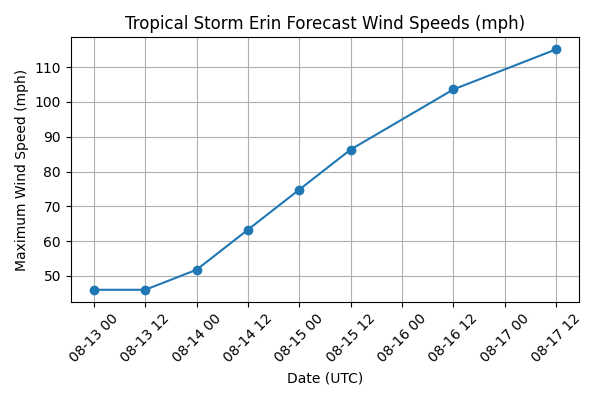
The NHC’s 1500 UTC forecast advisory tracks Erin westward through Thursday and then west‑northwest toward the central tropical Atlantic. Forecast points show steady intensification, with winds increasing to 45 kt (52 mph) by Thursday morning, 65 kt (75 mph) by Friday night, 90 kt (104 mph) by Saturday afternoon near 19.8 °N, 60.3 °W, and 100 kt (115 mph) by Sunday afternoon near 21.4 °N, 65.0 °W. The graphic below illustrates the projected wind speeds over time.
An analysis of the European (ECMWF), U.S. GFS and experimental Google model ensembles by Yale Climate Connections indicates that nearly all ensemble members recurved Erin to the north and northeast before reaching the Caribbean. This consensus stems from a predicted upper‑level trough moving across eastern North America that will steer the storm away. Sea‑surface temperatures along Erin’s path are providing ample fuel for strengthening. Light to moderate wind shear and a moist atmosphere support intensification.
Despite this agreement, forecasts caution that the sharp northward turn may not occur until a week from now. If the Bermuda high remains stronger than expected, Erin could track farther west before curving, bringing it closer to the Virgin Islands and Puerto Rico. Conversely, a faster or earlier turn would send the storm toward Bermuda.
Weather Underground’s hurricane tracker lists Erin’s position and intensity consistent with NHC data (17.2 °N, 36.3 °W; winds 45 mph; pressure 1006 mb). Weather.com notes that Erin will head toward warmer waters in the coming days, allowing it to strengthen into a hurricane, but provides no evidence of a threat to land at this time. The site emphasizes that even without landfall, large swells and rip currents could reach north‑facing Caribbean beaches later this week.
Potential Impacts on the U.S. Virgin Islands and Puerto Rico
Although Erin currently poses no direct threat, its future path requires close monitoring. Key points for residents and visitors:
-
Timing and Strength: Erin could reach major hurricane status (Category 3) by Saturday, when it may be near 20 °N, 60 °W — still well east of the Caribbean but potentially close enough for peripheral impacts. Forecast models place the storm’s center 400–500 miles northeast of the Leeward Islands by Sunday.
-
Wind and Rain: If the storm tracks farther west than expected, tropical‑storm‑force winds could brush the northern Leeward Islands, St. John, St. Thomas, and St. Croix early next week. However, current models show the wind field remaining compact, with tropical‑storm‑force winds extending only about 35 miles from the center.
-
High Surf and Rip Currents: Even without a landfall, Erin is expected to generate large swells and dangerous rip currents along east‑ and north‑facing coasts of the Virgin Islands and Puerto Rico beginning this weekend. Beachgoers should heed surf advisories and avoid swimming in rough surf.
-
Rainfall: Should the storm pass closer to the islands, outer rainbands could bring brief heavy showers and gusty squalls. Residents in flood‑prone areas should prepare for localized flooding.
-
Preparedness: Residents are urged to update hurricane plans and review emergency supplies now. Track forecasts can shift, and the storm could be near the region as a hurricane by the weekend


Advertisements


