


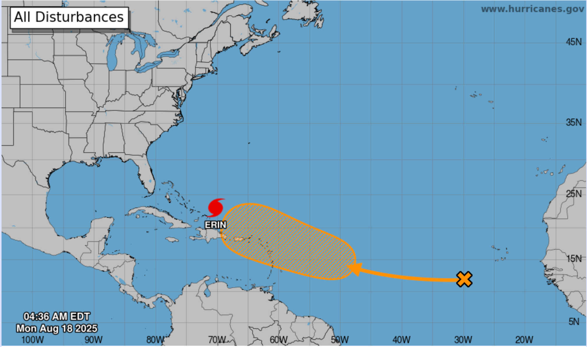
NHC's 7-day tropical weather outlook map as of 4:36 AM on Mon., August 18, 2025, showing Hurricane Erin north of the Caribbean and a tropical disturbance over the eastern Atlantic. Photo Credit: NATIONAL HURRICANE CENTER.
The National Hurricane Center’s 2:00 a.m. Tropical Weather Outlook reports a large area of disorganized showers and thunderstorms over the eastern tropical Atlantic associated with a tropical wave. Environmental conditions are conducive for gradual development, and a tropical depression could form during the latter part of the week as the system travels westward to west‑northwestward at about 20 mph. Current model guidance and the NHC indicate that this disturbance could approach the vicinity of the Leeward Islands on Friday.

-
Development odds: The NHC assigns a near‑zero percent chance of development over the next 48 hours but a 50 % chance of formation through seven days. Ensemble guidance from the European Centre for Medium‑Range Weather Forecasts (ECMWF) and other global models suggests that some members consolidate the wave into a tropical cyclone, while many keep it weak and disorganized. Most tracks point toward a west‑northwestward path across the central Atlantic, potentially bringing the system near the northern Leeward Islands, the U.S. Virgin Islands and Puerto Rico by the end of the week. However, dry Saharan air and increasing wind shear could inhibit rapid development, and there remains significant uncertainty.
-
Implications for the Leeward Islands: Residents and visitors in St. Thomas, St. John, St. Croix, Puerto Rico and the northern Leeward Islands should monitor this system throughout the week. Even if the wave remains weak, increased moisture could bring showers, gusty winds and higher seas toward the end of the week.
What the Models Say
NHC & GFS/ECMWF: The NHC’s forecast models show the eastern Atlantic tropical wave moving steadily west‑northwest across the Atlantic. The Global Forecast System (GFS) and ECMWF ensembles generally agree on a track toward the northern Leeward Islands, though timing and intensity vary. ECMWF ensembles show a range of solutions, from a weak wave bringing scattered showers to a tropical storm near the islands late in the week. GFS ensembles depict a similar path but with more members developing a closed circulation. Overall, the model consensus supports gradual strengthening but keeps the system below hurricane strength before it nears the Caribbean. Confidence remains low due to the system’s current disorganization and the influence of dry Saharan air.
Weather Underground: Weather Underground’s tropical update pages (which rely on official data) also highlight the new tropical wave, noting that it has a medium chance of development later this week and could affect the northern Leeward Islands. Their storm tracker (which previously tracked Hurricane Erin) will display Invest‑numbered storms once the NHC designates the system. For now, it lists the wave as a 50 % formation chance over seven days, echoing the NHC’s outlook.
Current Status of Hurricane Erin
While eyes shift to the new wave, Hurricane Erin continues to churn to the north of the Caribbean. At 5:00 a.m. EDT, Erin’s eye was located near 22.8 °N, 70.2 °W, about 105 miles north‑northeast of Grand Turk Island and roughly 915 miles south‑southeast of Cape Hatteras. Erin is a Category 4 hurricane with maximum sustained winds of 130 mph (215 km/h) and is moving northwest at 13 mph. The NHC expects Erin to turn north later today, passing east of the southeastern Bahamas, and then to move between Bermuda and the U.S. East Coast by mid‑week.
Erin’s hurricane‑force winds extend out to 80 miles, with tropical‑storm‑force winds up to 230 miles. Although Erin poses no direct threat to the U.S. Virgin Islands or Puerto Rico, its swells will continue to impact the region. Swells and surf generated by Erin will reach the Bahamas, Bermuda, the East Coast of the United States and Atlantic Canada during the coming days and will likely cause life‑threatening surf and rip currents.
Local Outlook for the U.S. Virgin Islands and Puerto Rico (Mon Aug 18 – Wed Aug 20)
Although the immediate threat from Erin has passed, residual moisture and south‑southwesterly flow will continue to produce scattered showers and isolated thunderstorms in the Virgin Islands and Puerto Rico through Monday and Tuesday. Conditions gradually improve mid‑week as the ridge rebuilds, but high surf and rip currents remain a hazard.
St. Thomas and St. John
-
Monday: Breezy and mostly cloudy with scattered showers and isolated thunderstorms. Highs near 89 °F. South winds 15–20 mph with gusts up to 30 mph; rain chance 50 %.
-
Monday Night: Variably cloudy with scattered showers. Lows around 82 °F; south winds 10–15 mph; rain chance 30 %.
-
Tuesday: Variably cloudy with scattered showers. Highs around 94 °F. Seas will remain rough due to Erin’s swells.
St. Croix
-
Monday: Breezy; mostly cloudy with scattered showers and isolated thunderstorms. Highs near 90 °F. South winds 15–20 mph with gusts up to 25 mph; rain chance 50 %.
-
Monday Night: Variably cloudy with scattered showers. Lows near 81 °F; southeast winds 10–15 mph; rain chance 30 %.
-
Tuesday: Variably cloudy with scattered showers. Highs around 94 °F; rain chance 30 %.
Looking Ahead

Tuesday through Friday: High pressure north of the region should return more typical trade‑wind conditions by mid‑week, with scattered showers and highs in the mid‑90s. By Thursday or Friday, the eastern Atlantic tropical wave could approach the Leeward Islands. If it organizes, the system may bring increased showers, thunderstorms and gusty winds to the U.S. Virgin Islands and Puerto Rico late in the week. Residents should stay informed and review preparedness plans in case watches or warnings are issued.


Advertisements


