


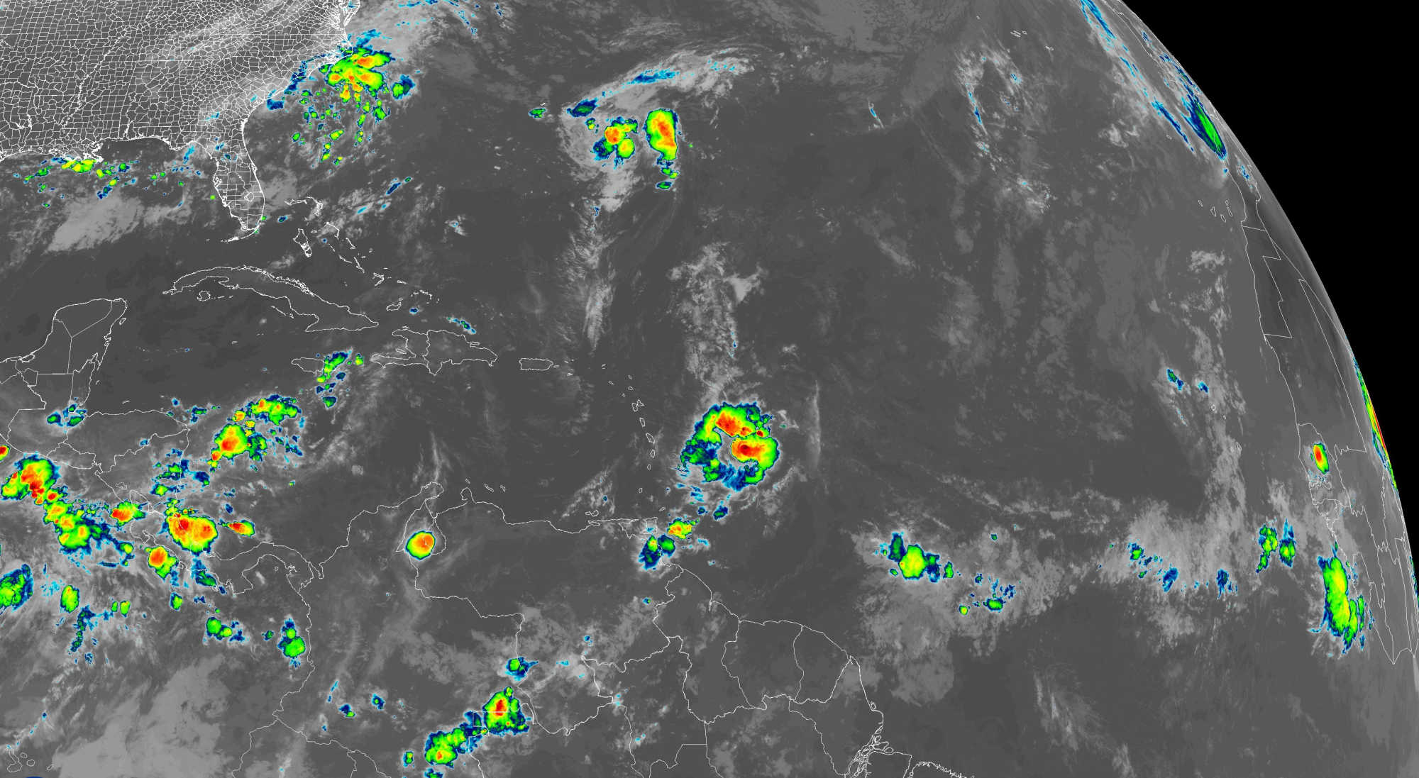
The Atlantic basin continues to show activity as Tropical Storm Fernand moves across open waters while a disturbance east of the Windward Islands approaches the Lesser Antilles with chances of further development. Another weak wave in the far eastern Atlantic remains poorly organized. For the Virgin Islands and Puerto Rico, the main impacts through the start of the week will be gusty trade winds, hazy skies, and occasional showers, with lingering swells from former Hurricane Erin keeping surf conditions hazardous.

Tropical Storm Fernand
According to the National Hurricane Center’s Sunday update, Tropical Storm Fernand was located near 29.7°N 60.7°W, about 260 nautical miles southeast of Bermuda. The system carried maximum sustained winds of 40 mph while moving north-northeast at 13 knots. Fernand is expected to continue tracking northeastward, staying well east of Bermuda before weakening by Tuesday. While a slight strengthening phase is possible in the short term, the storm is not a threat to the Caribbean and will remain confined to open waters.
Disturbance Near the Windward Islands
A tropical wave approximately 450 miles east of the Windward Islands is showing increased shower and thunderstorm activity. The NHC has given the disturbance a 40 percent chance of development over the next two days and through seven days, with the potential to become a tropical depression as it crosses the Leeward Islands late Sunday into Monday. The system is moving quickly west at 20–25 mph, bringing the likelihood of heavy rainfall and gusty winds to the Windward and Leeward Islands. Beyond Tuesday, conditions in the central Caribbean become less favorable, limiting chances for further strengthening. Eastern Atlantic Wave
Another wave along 26°W in the eastern Atlantic is drifting slowly westward. At present, convection is minimal and environmental conditions do not support organization. While models hint at a low chance of gradual development, any potential system would remain days away from affecting the Caribbean.
Residual Swells From Erin
Large swells generated by post-tropical Erin are still producing seas of 8–11 feet across parts of the central Atlantic. These swells are expected to diminish by Monday, but hazardous surf and rip currents will continue to impact north-facing beaches of Puerto Rico and the U.S. Virgin Islands through the start of the week.
Local Forecast
St. Thomas & St. John: Partly cloudy skies with isolated showers and widespread haze are forecast. Highs will reach around 94°F with heat indices above 100°F. East winds of 15–20 mph, gusting to 30 mph, will persist. A heat advisory, high surf advisory, and rip current statement remain in effect. Tonight will be breezy with lows near 82°F. Similar hazy, breezy conditions are expected Monday and Tuesday with occasional showers.
St. Croix: The island will also see partly cloudy skies, scattered haze, and breezy trade winds. Highs today are expected near 94°F with gusts up to 30 mph. Conditions remain the same tonight with lows near 82°F. Monday and Tuesday will continue with hazy skies, isolated showers, and highs around 92–93°F. Advisories for heat and rip currents remain active.
Puerto Rico (San Juan Area): The forecast calls for partly cloudy skies early with scattered showers developing by the afternoon. Highs will reach 93°F, with east winds of 10–15 mph and gusts up to 25 mph. Tonight will be partly cloudy with isolated showers and lows near 82°F. Monday will bring isolated showers and highs around 90°F, while Tuesday will see scattered afternoon showers with highs near 89°F. A high surf advisory, rip current statement, and extreme heat warning remain in effect.
3-Day Outlook (Mon-Wed)
-
Fernand: Moves northeast and weakens, no threat to the Caribbean.
-
Disturbance Near Windward Islands: May become a depression as it crosses the Leeward Islands Monday; limited strengthening expected beyond that.
-
Local Impacts: Breezy trade winds, hazy skies, and isolated showers will persist. Swells from Erin will gradually subside.
7-Day Outlook
High pressure across the subtropical Atlantic will maintain strong trade winds and haze over the region through late week. The disturbance near the Windward Islands is expected to weaken over the central Caribbean midweek, leaving behind a moist but weak trough. The eastern Atlantic wave may see gradual improvement in conditions but is currently expected to remain weak and track north of the islands.
Safety and Preparation
-
Heat Precautions: With heat indices exceeding 100°F, residents are advised to stay hydrated, avoid prolonged outdoor activity during peak hours, and wear protective clothing.
-
Surf and Rip Currents: Hazardous conditions from Erin’s swells will persist through Monday. Swimmers should follow local advisories and beach flag warnings.
-
Passing Showers: Keep umbrellas handy for scattered rainfall, especially Monday and Tuesday afternoons.
-
Stay Informed: NHC advisories are issued four times daily at 2 a.m., 8 a.m., 2 p.m., and 8 p.m. EDT, with additional updates as necessary.


Advertisements


