


 77°F
77°F

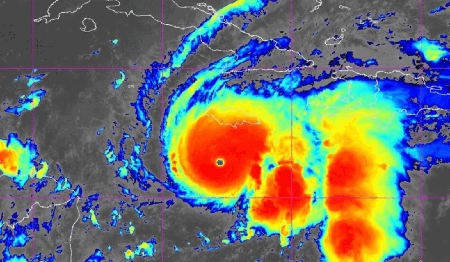
A NOAA satellite image shows the symmetrical eye of Category 5 Hurricane Melissa south of Jamaica, revealing the storm’s explosive intensification. Photo Credit: NOAA.
The National Hurricane Center (NHC) has confirmed that Hurricane Melissa has intensified into a Category 5 hurricane, prompting widespread emergency preparations across Jamaica, which now appears squarely in the storm’s path.

As of 5 a.m. on Monday, October 27, Melissa’s sustained winds had reached 160 mph (260 km/h) with a minimum central pressure of 917 millibars. The hurricane’s center was located near 16.4° N and 77.8° W, about 130 miles (205 km) south-southwest of Kingston and drifting west at 3 mph (6 km/h). Forecasters warned that the storm’s slow movement will prolong exposure to torrential rain, destructive winds, and life-threatening storm surge.
A Hurricane Warning is in effect for Jamaica and for Cuba’s eastern provinces of Granma, Santiago de Cuba, Guantánamo, and Holguín.
A Hurricane Watch covers the southeastern and central Bahamas and the Turks and Caicos Islands, while a Tropical Storm Warning remains active for Haiti and Cuba’s Las Tunas province. The NHC stressed that preparations to protect life and property should already be completed, as hurricane conditions are expected within 36 hours.
Air Force Reserve Hurricane Hunter aircraft measured flight-level winds of 154 knots and confirmed a central pressure of 917 mb inside Melissa’s eye — signs of an extremely powerful storm. The hurricane’s eye is just 10 nautical miles wide and surrounded by cloud tops colder than –86 °C, evidence of deep convection and explosive intensification. Melissa is expected to gradually turn northwest and then north before accelerating northeastward across southeastern Cuba and the Bahamas by midweek.
Jamaicans rushed to complete last minute preparations, purchasing battery or solar powered radios, lights, and power banks. Authorities ordered evacuations of several low-lying areas across the country, including Port Royal in Kingston. “I urge Jamaicans to take this weather threat seriously,” said Prime Minister Andrew Holness.
Across the country, residents took his advice seriously. Sandbags were filled, roofs secured, and windows boarded up. A few hundred people, as of press time, have already relocated to shelters. Some who called Port Royal home, however, have decided to stay put. “Father God will protect us,” Ann Marie Chamberlain told Guardian reporters. She described unsafe conditions at the shelter during a hurricane two decades ago, and said she preferred to take her chances at home.
For many Jamaicans awaiting the arrival of Hurricane Melissa, social media is helping to ease the anxiety of anticipation once all hurricane preparedness tasks are completed and there is nothing else to do but wait.
One resident posted a photo featuring a bowl of fruit known in Jamaica as Otaheite apple, claiming that “Melissa nah get dem.”
Others banded together to chastise a cohort of foreign “storm chasers” who were perceived to be almost gleefully predicting annihilation for Jamaica in the face of the hurricane's impending passage.
Entrepreneur Odetta Rockhead-Kerr posted clips of her well-manicured garden, captioned “before Hurricane Melissa.” The video was accompanied by a song whose lyrics spoke about the preparations Ms. Rockhead-Kerr had made to protect her precious plants and the koi in her pond, ending with an assurance that no matter what damage the hurricane wreaks on the tranquil environment, she – and Jamaica – will persevere. “When she gone me go sweep me yard, plant again, life sweet though hard,” she sings.
The NHC noted that its track forecast was adjusted slightly westward after Google DeepMind’s AI hurricane model and the European Centre for Medium-Range Weather Forecasts (ECMWF) both projected Melissa passing closer to Jamaica and the western Atlantic. These models have shown high accuracy this season, and their consensus suggests Melissa’s eye will likely cross Jamaica’s southern coast before curving northward. The official forecast keeps Melissa at major hurricane strength through its journey over Cuba and the Bahamas.
The storm is moving over waters with very high ocean heat content and low vertical wind shear, conditions that support further strengthening before landfall. Although eyewall replacement cycles could cause brief fluctuations, forecasters emphasized that “there is little practical difference between a Category 4 and Category 5 landfall, as both can produce catastrophic wind damage.” Interaction with Jamaica’s mountainous terrain may weaken Melissa slightly, but the storm is still expected to reach southeastern Cuba as a major hurricane.
Tropical-storm conditions were already spreading across Jamaica by dawn Monday, and destructive hurricane-force winds are expected through Tuesday. Hurricane-force winds extend 30 miles (45 km) from the center, while tropical-storm winds reach 195 miles (315 km). The NHC warned that winds over hills and windward slopes could be 30 percent stronger, producing gusts exceeding 180 mph (290 km/h) in mountainous areas.
Melissa is forecast to deliver 15–30 inches (380–760 mm) of rain across much of Jamaica, with local maximum totals of 40 inches (1,000 mm). Such rainfall will cause catastrophic flash flooding and numerous landslides. For comparison, Kingston typically receives just over 800 millimeters of rain in an entire year — Melissa could deliver that in 24 hours. In southern Haiti and Hispaniola, similar totals could trigger devastating floods and mudslides.
A life-threatening storm surge of 9 to 13 feet above ground level is expected along Jamaica’s southern coast, especially east of the landfall point. The NHC warned that Norman Manley International Airport and other low-lying areas around Kingston could be inundated by surge and large waves. Surge heights of 6–9 feet are also possible along southeastern Cuba and later in the southeastern Bahamas.
Meteorologists note that Melissa could be the most intense hurricane ever to strike Jamaica. No Category 4 or 5 storm has made a direct landfall on the island in recorded history. Only two Category 5 hurricanes — Allen (1980) and Ivan (2004) — passed close by without landfall. With 160 mph winds, Melissa may surpass the famed Hurricane Gilbert (1988), which brought 130 mph gusts to the island.
The NHC projects Melissa will reach 16.6° N, 78.1° W with 165 mph winds by Monday afternoon, then 17.3° N, 78.1° W early Tuesday with 160 mph winds. The storm is forecast to cross Jamaica Tuesday morning, emerge off the north coast by afternoon, and move toward southeastern Cuba Tuesday night before reaching the Bahamas Wednesday still as a major hurricane.
Residents are urged to shelter in sturdy structures and avoid coastal areas. The NHC warned: “Do not venture out of your safe shelter. Catastrophic and life-threatening flash flooding and numerous landslides are likely.” Officials also cautioned that extended power and communication outages are expected and that supplies should be secured for several days.
The public is advised to monitor updates from the Meteorological Service of Jamaica and the Office of Disaster Preparedness and Emergency Management (ODPEM), which have initiated flood and landslide evacuations in vulnerable areas.
After crossing Jamaica, Melissa is forecast to weaken slightly yet remain a major hurricane as it moves over eastern Cuba and into the southeastern Bahamas. Even after the eye passes, Jamaica could experience bands of heavy rain and gusty winds for days. Recovery efforts may be hampered by flooding, debris, and damaged infrastructure. Authorities urge residents to stay indoors until officials declare conditions safe.

With Category 5 winds, record-breaking rainfall, and surge up to 13 feet, Hurricane Melissa poses an unprecedented threat to Jamaica. AI-enhanced forecast models and NHC data agree that the hurricane’s core will strike the island before turning toward Cuba and the Bahamas. Forecasters warn that the storm will be remembered for generations — and that decisive preparation now can save lives.


