


 77°F
77°F

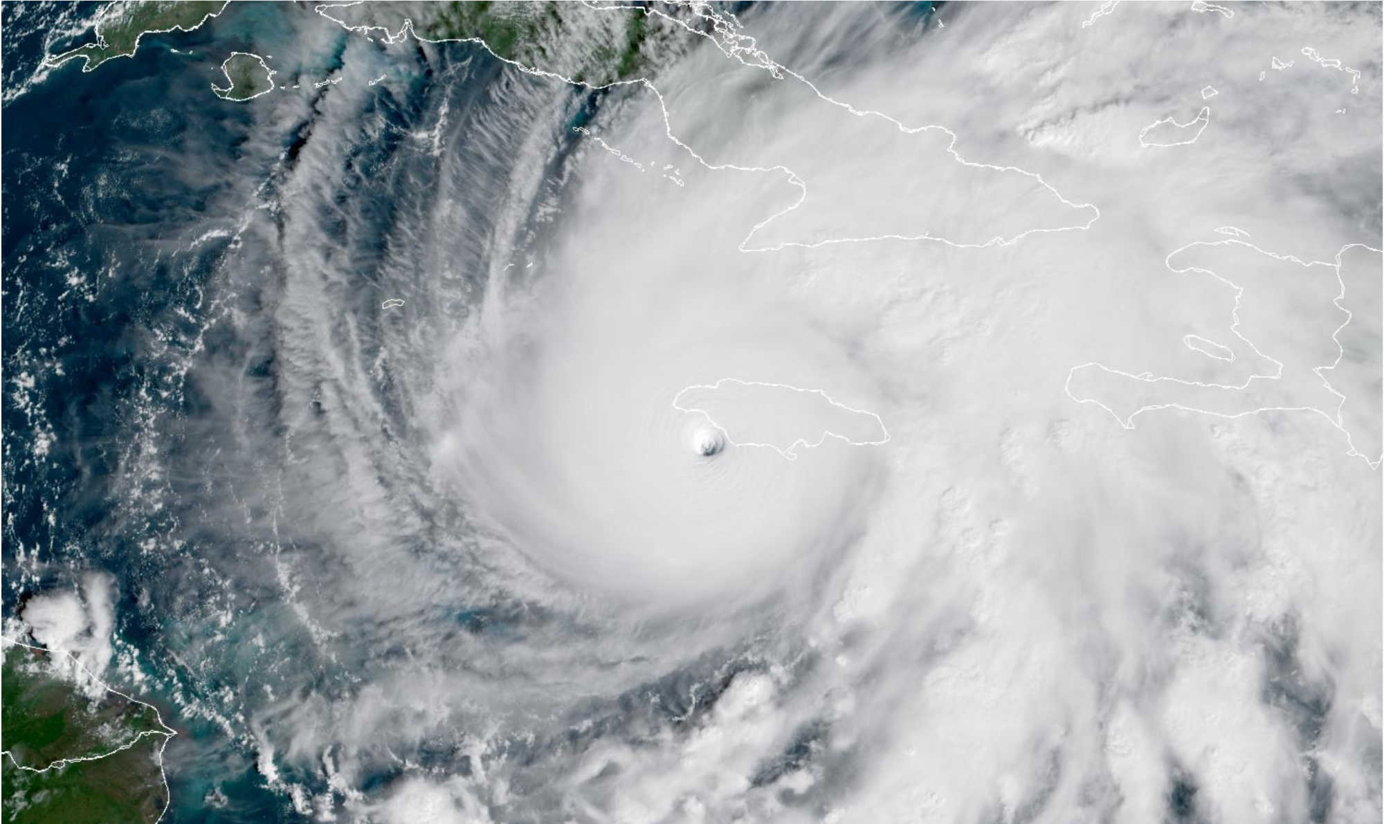
A NOAA satellite image shows the massive, symmetrical eye of Hurricane Melissa as it bears down on Jamaica. Photo Credit: NOAA.
Hurricane Melissa intensified overnight into one of the most powerful storms ever recorded in the Atlantic Basin, with sustained winds of 185 mph (295 km/h) and a minimum central pressure of 892 mb, according to the National Hurricane Center (NHC). The Category 5 hurricane is now 40 miles (60 km) southeast of Negril, moving north-northeast at 9 mph, and is expected to make landfall on Jamaica within hours, unleashing catastrophic winds, storm surge, and flooding across the island.

At 10 a.m. Tuesday, Melissa tied the 1935 Labor Day Hurricane and 2019’s Hurricane Dorian as the third most intense Atlantic hurricane on record by wind speed. NHC forecasters warned that Melissa will likely be the strongest hurricane ever to strike Jamaica, bringing life-threatening winds, torrential rainfall, and storm surge that could submerge coastal communities.
Widespread Warnings Across the Region
Hurricane warnings are in effect for Jamaica, as well as Cuba’s Granma, Santiago de Cuba, Guantánamo, Holguín, and Las Tunas provinces, and for the southeastern and central Bahamas. Tropical storm warnings also cover Haiti, Cuba’s Camagüey province, and the Turks and Caicos Islands. Residents in all affected regions were urged to remain sheltered, with the NHC stressing that preparations should be completed immediately. Bermuda may also face impacts later this week, with watches expected to be issued soon.
Devastating Conditions Expected on Jamaica
The NHC said catastrophic hurricane-force winds are spreading across Jamaica and warned of “total structural failure” near Melissa’s core, particularly in mountainous terrain where winds can increase by up to 30 percent. Hurricane Hunter aircraft measured wind gusts near 250 mph at 1,500 feet, and forecasters said gusts above 200 mph could occur on Jamaica’s highest peaks, tearing roofs from buildings, uprooting trees, and rendering travel impossible.
Melissa is forecast to drop 15 to 30 inches (380–760 mm) of rain across Jamaica, with localized totals up to 40 inches (1,000 mm). The rainfall will cause catastrophic flash flooding, landslides, and prolonged isolation in affected areas. Rivers are expected to rise quickly as saturated hillsides give way, cutting off entire communities for days.
Along Jamaica’s southern coast, storm surge levels of 9 to 13 feet are expected, accompanied by large, destructive waves capable of flooding coastal towns and destroying infrastructure. Near Montego Bay, surge heights may reach 2 to 4 feet, while dangerous surf and rip currents will batter Jamaica, Hispaniola, eastern Cuba, and the Cayman Islands before spreading to the Bahamas and Bermuda later this week.
Forecast Track and Next Threats
Melissa’s eye will cross Jamaica later Tuesday before moving across southeastern Cuba early Wednesday and the southeastern or central Bahamas by Wednesday night. The storm will then accelerate northeastward toward the open Atlantic and possibly pass near Bermuda on Thursday night. Though gradual weakening is expected as it interacts with land, the NHC said Melissa will remain a major hurricane through its passage over Cuba and the Bahamas.
The NHC attributed Melissa’s slight westward track adjustment to guidance from Google DeepMind’s AI model and the European Centre for Medium-Range Weather Forecasts (ECMWF), both showing a direct hit on Jamaica before curving northeast.
After Landfall: Prolonged Destruction and Isolation
The NHC issued a stark warning early Tuesday, calling the storm “a last chance to protect your life.” Residents were urged not to leave shelter during the calm of the eye, as the return of the eyewall will bring a second round of devastating winds. Communications in southwestern Jamaica are expected to fail due to massive damage, meaning updates from the region could be unavailable for hours or even days.
Officials warned that power, communication, and transport systems will likely be crippled, urging residents to stock food, water, and medical supplies for several days. Jamaica’s government opened hundreds of emergency shelters, though as of Monday evening, only about 1,000 people had sought refuge.

With 185 mph winds, up to 40 inches of rainfall, and 13-foot storm surges, Hurricane Melissa poses an unprecedented threat to Jamaica. The National Hurricane Center is urging all residents to remain in secure shelters and not venture outdoors under any circumstance. The storm’s impacts are expected to be catastrophic and long-lasting, with Jamaica facing one of the most powerful hurricanes ever recorded in its history.